Convenience store nearby Rite Stop Gas & Food
United States
Convenience store nearby Rite Stop Gas & Food
Rite Stop Gas & Food
26 Manchester Road, Poughkeepsie Israel
contacts phone
:
+1
Latitude:
41.6941334
, Longitude:
-73.8939338
read more
nearest Convenience store
Рит Стоп Гас & Фуд
26 Manchester Road, Poughkeepsie
Convenience store
read more
637 m
Smokes 4 Less
2 Raymond Avenue, Poughkeepsie
Convenience store
read more
822 m
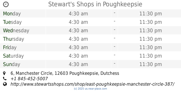
Stewart's Shops
6 Manchester Circle, Poughkeepsie
Convenience store
read more
986 m
Саноко Конвениенс Март
740 Main Street, Poughkeepsie
Convenience store
read more
986 m
Sunoco Convenience Mart
740 Main Street, Poughkeepsie
Convenience store
read more
1.215 km
Rite Aid
709 Main Street, Poughkeepsie
Convenience store
read more
1.337 km
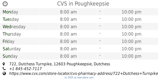
CVS
722 Dutchess Turnpike, Poughkeepsie
Convenience store
read more
1.576 km
7-Eleven
266 Hooker Avenue, Poughkeepsie
Convenience store
read more
1.69 km
Rite Aid
238 Hooker Avenue, Poughkeepsie
Convenience store
read more
1.784 km
Sam's Mart
United States
Convenience store
read more
1.785 km
Innis Food Mart Krispy Krunchy Chicken
174 Innis Avenue, Poughkeepsie
Convenience store
read more
2.025 km
La Michoacana
537 Main Street, Poughkeepsie
Convenience store
read more
2.06 km
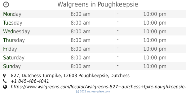
Walgreens
827 Dutchess Turnpike, Poughkeepsie
Convenience store
read more
2.062 km
Rite Stop Gas & Food Mart
531 Main Street #533, Poughkeepsie
Convenience store
read more
2.162 km
Gautam Corporation
70 Mitchell Avenue, Poughkeepsie
Convenience store
read more
📑
all categories
Accounting
Administrative area level 1
Administrative area level 2
Airport
Amusement park
Aquarium
Art gallery
Atm
Bakery
Bank
Bar
Beauty salon
Bicycle store
Book store
Bowling alley
Bus station
Cafe
Campground
Car dealer
Car rental
Car repair
Car wash
Casino
Cemetery
Church
City hall
Clothing store
Colloquial area
Convenience store
Courthouse
Dentist
Department store
Doctor
Electrician
Electronics store
Embassy
Establishment
Finance
Fire station
Florist
Food
Funeral home
Furniture store
Gas station
General contractor
Grocery or supermarket
Gym
Hair care
Hardware store
Health
Hindu Temple
Home goods store
Hospital
Insurance agency
Intersection
Jewelry store
Laundry
Lawyer
Library
Light rail station
Liquor store
Local government office
Locality
Locksmith
Lodging
Meal delivery
Meal takeaway
Mosque
Movie rental
Movie theater
Moving company
Museum
Natural feature
Neighborhood
Night club
Painter
Park
Parking
Pet store
Pharmacy
Physiotherapist
Place of worship
Plumber
Point of interest
Police
Political
Post office
Premise
Real estate agency
Restaurant
Roofing contractor
Route
Rv park, camping
School
Shoe store
Shopping mall
Spa
Stadium
Storage
Store
Subpremise
Subway station
Supermarket
Synagogue
Taxi stand
Train station
Transit station
Travel agency
University
Veterinary care
Zoo
administrative area level 3
sublocality level 1
↑