Cafe nearby McDonald's
Coronavirus disease (COVID-19) Situation
confirmed cases
111820082
deaths
1219487
United States
Cafe nearby McDonald's
McDonald's
8651, North Freeway Service Road West, 76140, Fort Worth, Tarrant County, US United States
contacts phone
:
+1 817-293-1672
website:
www.mcdonalds.com
Latitude:
32.6281013
, Longitude:
-97.3205397
larger map & directions
read more
nearest Cafe
Макдоналдс
8651 North Freeway Service Road West, Fort Worth
Cafe
read more
45 m
Starbucks
8601 South Freeway, Fort Worth
Cafe
read more
2.758 km
Shipley Do-Nuts
7701 Crowley Road #101, Fort Worth
Cafe
read more
4.37 km
City Blends Smoothies
123 Thelin Street, Fort Worth
Cafe
read more
4.482 km
Макдоналдс
7451 McCart Avenue, Fort Worth
Cafe
read more
4.661 km
Starbucks
7441 McCart Avenue, Fort Worth
Cafe
read more
5.042 km
McDonald's
3500 Altamesa Boulevard, Fort Worth
Cafe
read more
5.042 km
Макдоналдс
3500 Altamesa Boulevard, Fort Worth
Cafe
read more
5.206 km
McDonald's
3200 Southeast Loop 820, Forest Hill
Cafe
read more
5.206 km
Макдоналдс
3200 Southeast Loop 820, Forest Hill
Cafe
read more
5.419 km
Starbucks
3221 East California Parkway, Forest Hill
Cafe
read more
5.56 km
Manolo
5650 Odessa Avenue, Fort Worth
Cafe
read more
5.622 km
Shipley Do-Nuts
3300 Southeast Loop 820, Fort Worth
Cafe
read more
12.873 km
Dunkin'
5801 Office Park Drive, Arlington
Cafe
Bakery
Meal takeaway
Restaurant
Store
Food
Point of interest
Establishment
read more
16.997 km
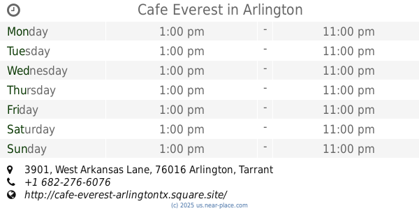
Cafe Everest
3901 West Arkansas Lane #107A, Arlington
Restaurant
Cafe
Store
Point of interest
Food
Establishment
read more
📑
all categories
Accounting
Administrative area level 1
Administrative area level 2
Airport
Amusement park
Aquarium
Art gallery
Atm
Bakery
Bank
Bar
Beauty salon
Bicycle store
Book store
Bowling alley
Bus station
Cafe
Campground
Car dealer
Car rental
Car repair
Car wash
Casino
Cemetery
Church
City hall
Clothing store
Colloquial area
Convenience store
Courthouse
Dentist
Department store
Doctor
Electrician
Electronics store
Embassy
Establishment
Finance
Fire station
Florist
Food
Funeral home
Furniture store
Gas station
General contractor
Grocery or supermarket
Gym
Hair care
Hardware store
Health
Hindu Temple
Home goods store
Hospital
Insurance agency
Intersection
Jewelry store
Laundry
Lawyer
Library
Light rail station
Liquor store
Local government office
Locality
Locksmith
Lodging
Meal delivery
Meal takeaway
Mosque
Movie rental
Movie theater
Moving company
Museum
Natural feature
Neighborhood
Night club
Painter
Park
Parking
Pet store
Pharmacy
Physiotherapist
Place of worship
Plumber
Point of interest
Police
Political
Post office
Premise
Real estate agency
Restaurant
Roofing contractor
Route
Rv park, camping
School
Shoe store
Shopping mall
Spa
Stadium
Storage
Store
Subpremise
Subway station
Supermarket
Synagogue
Taxi stand
Train station
Transit station
Travel agency
University
Veterinary care
Zoo
administrative area level 3
sublocality level 1
↑