Establishment nearby Papa Johns Pizza
United States
Establishment nearby Papa Johns Pizza
Papa Johns Pizza
5395, West 38th Avenue, 80212, Denver, Jefferson County, US United States
contacts phone
:
+1 303-456-6262
website:
locations.papajohns.com
Latitude:
39.7697848
, Longitude:
-105.0554285
larger map & directions
read more
nearest Establishment
20 m
Subway
5397 West 38th Avenue, Wheat Ridge
Meal takeaway
Restaurant
Food
Point of interest
Establishment
read more
84 m
Coinstar Kiosk | Bitcoin ATM
Kroger - King Soopers, 5301 West 38th Avenue, Denver
Atm
Finance
Point of interest
Store
Establishment
read more
738 m
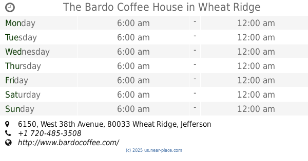
The Bardo Coffee House
6150 West 38th Avenue, Wheat Ridge
Cafe
Restaurant
Food
Store
Point of interest
Establishment
read more
748 m
Orthodontics in the Highlands
4390 Sheridan Boulevard, Denver
Dentist
Health
Point of interest
Establishment
read more
756 m
Dr. Lia D. Baros, DDS
4390 Sheridan Boulevard, Denver
Dentist
Health
Point of interest
Establishment
read more
766 m
Dr. Brian Fangman - Altitude Oral and Facial Surgery
5600 West 44th Avenue, Denver
Doctor
Dentist
Health
Point of interest
Establishment
read more
839 m
Lighthouse Apartments
6130 West 40th Avenue, Wheat Ridge
Lodging
Point of interest
Establishment
read more
868 m
Primary Dental
5801 West 44th Avenue Unit C, Denver
Dentist
Doctor
Health
Point of interest
Establishment
read more
871 m
Devil's Cup Coffee
4999 West 44th Avenue, Denver
Cafe
Store
Point of interest
Food
Establishment
read more
939 m
38 th plaza
6279 West 38th Avenue, Wheat Ridge
Hospital
Health
Point of interest
Establishment
read more
944 m
Circle K
4498 Sheridan Boulevard, Denver
Convenience store
Gas station
Meal takeaway
Cafe
Store
Restaurant
Food
Point of interest
Establishment
read more
959 m
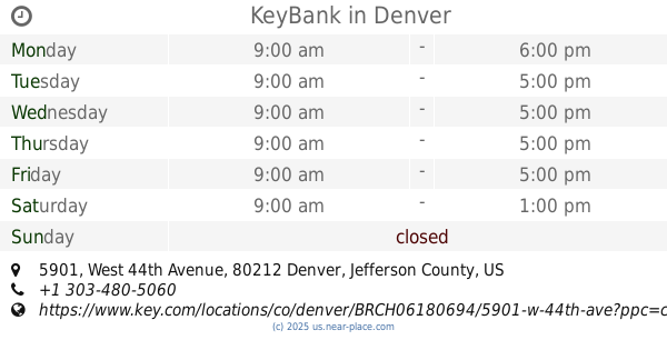
KeyBank
5901 West 44th Avenue, Denver
Bank
Atm
Finance
Point of interest
Establishment
read more
959 m
KeyBank ATM
5901 West 44th Avenue, Denver
Atm
Finance
Point of interest
Establishment
read more
979 m
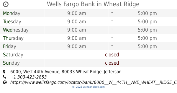
Wells Fargo Bank
6000 West 44th Avenue, Wheat Ridge
Bank
Atm
Finance
Point of interest
Establishment
read more
1.145 km
The Asher
4337 Tennyson Street, Denver
Lodging
Point of interest
Establishment
read more
📑
all categories
Accounting
Administrative area level 1
Administrative area level 2
Airport
Amusement park
Aquarium
Art gallery
Atm
Bakery
Bank
Bar
Beauty salon
Bicycle store
Book store
Bowling alley
Bus station
Cafe
Campground
Car dealer
Car rental
Car repair
Car wash
Casino
Cemetery
Church
City hall
Clothing store
Colloquial area
Convenience store
Courthouse
Dentist
Department store
Doctor
Electrician
Electronics store
Embassy
Establishment
Finance
Fire station
Florist
Food
Funeral home
Furniture store
Gas station
General contractor
Grocery or supermarket
Gym
Hair care
Hardware store
Health
Hindu Temple
Home goods store
Hospital
Insurance agency
Intersection
Jewelry store
Laundry
Lawyer
Library
Light rail station
Liquor store
Local government office
Locality
Locksmith
Lodging
Meal delivery
Meal takeaway
Mosque
Movie rental
Movie theater
Moving company
Museum
Natural feature
Neighborhood
Night club
Painter
Park
Parking
Pet store
Pharmacy
Physiotherapist
Place of worship
Plumber
Point of interest
Police
Political
Post office
Premise
Real estate agency
Restaurant
Roofing contractor
Route
Rv park, camping
School
Shoe store
Shopping mall
Spa
Stadium
Storage
Store
Subpremise
Subway station
Supermarket
Synagogue
Taxi stand
Train station
Transit station
Travel agency
University
Veterinary care
Zoo
administrative area level 3
sublocality level 1
↑