Convenience store nearby Walgreens
United States
Convenience store nearby Walgreens
Walgreens
4403, Colleyville Boulevard, 76034, Colleyville, Tarrant County, US Соединенные Штаты Америки
contacts phone
:
+1 817-514-9458
website:
www.walgreens.com
Latitude:
32.8739794
, Longitude:
-97.1628961
larger map & directions
read more
nearest Convenience store
100 m
Cash Technologies
4405 Colleyville Boulevard, Colleyville
Convenience store
read more
439 m
Техако
4612 Colleyville Boulevard, Colleyville
Convenience store
read more
1.211 km
7-Eleven
3900 Colleyville Boulevard, Colleyville
Convenience store
read more
1.22 km
Grapevine Food Mart
W Nw 760513007, 2041 Grapevine Highway, Colleyville
Convenience store
read more
2.24 km
Harwood Beer and Wine
2906 Brown Trail, Bedford
Convenience store
read more
2.298 km
7-Eleven
2900 Brown Trail, Bedford
Convenience store
read more
2.342 km
J's Q-Mart
6500 Precinct Line Road # A, Hurst
Convenience store
read more
2.396 km
Mini Mart
2829 Brown Trail, Bedford
Convenience store
read more
2.398 km
ALON Mini Mart
2829 Brown Trail, Bedford
Convenience store
read more
2.566 km
CVS
6401 Precinct Line Road, North Richland Hills
Convenience store
read more
2.674 km
M P Mart
1900 Norwood Drive, Hurst
Convenience store
read more
2.758 km
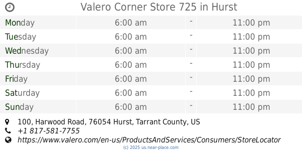
Valero Corner Store 725
100 Harwood Road, Hurst
Convenience store
read more
3.739 km
Central Deli
2901 Central Drive, Bedford
Convenience store
read more
3.739 km
Сентрал Дели
2901 Central Drive, Bedford
Convenience store
read more
3.781 km
CVS
2900 Central Drive, Bedford
Convenience store
read more
📑
all categories
Accounting
Administrative area level 1
Administrative area level 2
Airport
Amusement park
Aquarium
Art gallery
Atm
Bakery
Bank
Bar
Beauty salon
Bicycle store
Book store
Bowling alley
Bus station
Cafe
Campground
Car dealer
Car rental
Car repair
Car wash
Casino
Cemetery
Church
City hall
Clothing store
Colloquial area
Convenience store
Courthouse
Dentist
Department store
Doctor
Electrician
Electronics store
Embassy
Establishment
Finance
Fire station
Florist
Food
Funeral home
Furniture store
Gas station
General contractor
Grocery or supermarket
Gym
Hair care
Hardware store
Health
Hindu Temple
Home goods store
Hospital
Insurance agency
Intersection
Jewelry store
Laundry
Lawyer
Library
Light rail station
Liquor store
Local government office
Locality
Locksmith
Lodging
Meal delivery
Meal takeaway
Mosque
Movie rental
Movie theater
Moving company
Museum
Natural feature
Neighborhood
Night club
Painter
Park
Parking
Pet store
Pharmacy
Physiotherapist
Place of worship
Plumber
Point of interest
Police
Political
Post office
Premise
Real estate agency
Restaurant
Roofing contractor
Route
Rv park, camping
School
Shoe store
Shopping mall
Spa
Stadium
Storage
Store
Subpremise
Subway station
Supermarket
Synagogue
Taxi stand
Train station
Transit station
Travel agency
University
Veterinary care
Zoo
administrative area level 3
sublocality level 1
↑