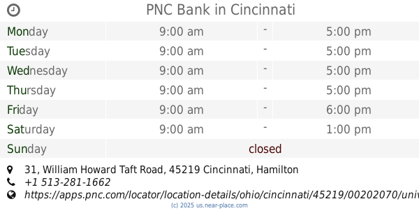
Atm nearby PNC Bank
United States
Atm nearby PNC Bank
PNC Bank
2501, Gilbert Avenue, 45206, Cincinnati, Hamilton County, US United States
contacts phone
:
+1 513-281-1734
website:
apps.pnc.com
Latitude:
39.12622
, Longitude:
-84.49057
larger map & directions
read more
nearest Atm
267 m
ATM (Marathon)
2340 Gilbert Avenue, Cincinnati
Atm
Finance
Point of interest
Establishment
read more
515 m
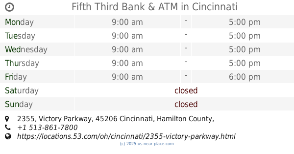
Fifth Third Bank & ATM
2355 Victory Parkway, Cincinnati
Bank
Atm
Finance
Point of interest
Establishment
read more
1.418 km
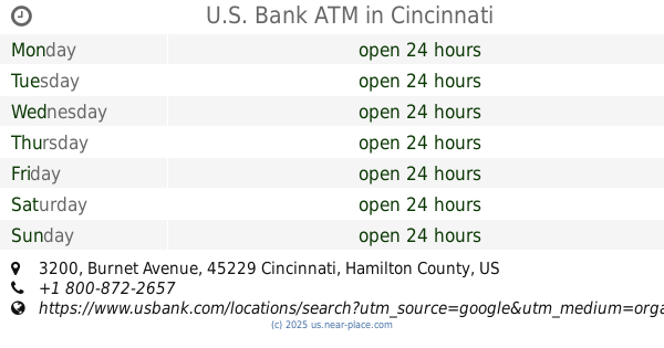
U.S. Bank ATM
3200 Burnet Avenue, Cincinnati
Atm
Finance
Point of interest
Establishment
read more
1.584 km
Superior Credit Union
49 William Howard Taft Road, Cincinnati
Atm
Finance
Point of interest
Establishment
read more
1.625 km
ecoATM
1 West Corry Street, Cincinnati
Atm
Finance
Store
Point of interest
Establishment
read more
1.66 km
First Financial Bank & ATM
2712 Short Vine Street, Cincinnati
Bank
Atm
Finance
Point of interest
Establishment
read more
1.666 km
PNC Bank
31 William Howard Taft Road, Cincinnati
Bank
Atm
Finance
Point of interest
Establishment
read more
1.687 km
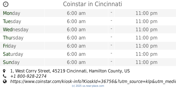
Coinstar
1 West Corry Street, Cincinnati
Atm
Finance
Store
Point of interest
Establishment
read more
1.707 km
Cincinnati Asian Market
1144, 2603 Vine Street, Cincinnati
Atm
read more
1.756 km
ATM (PNC Bank)
2902 Vine Street, Cincinnati
Atm
read more
1.784 km
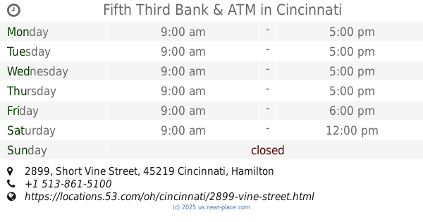
Fifth Third Bank & ATM
2899 Short Vine Street, Cincinnati
Bank
Atm
Finance
Point of interest
Establishment
read more
2.001 km
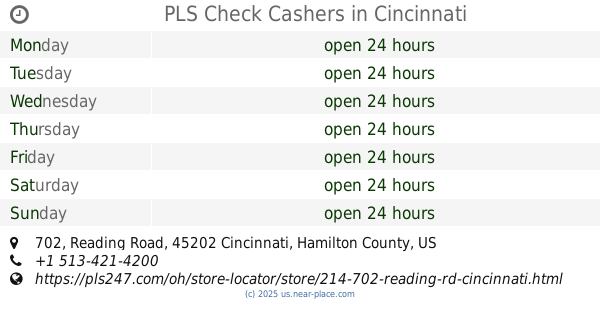
PLS Check Cashers
702 Reading Road, Cincinnati
Atm
Finance
Point of interest
Establishment
read more
2.106 km
Cardtronics ATM
136 6th Avenue, Dayton
Atm
read more
2.109 km
Access to Money
136 6th Avenue, Dayton
Atm
read more
2.15 km
BB&T ATM
118 6th Avenue, Dayton
Atm
read more
📑
all categories
Accounting
Administrative area level 1
Administrative area level 2
Airport
Amusement park
Aquarium
Art gallery
Atm
Bakery
Bank
Bar
Beauty salon
Bicycle store
Book store
Bowling alley
Bus station
Cafe
Campground
Car dealer
Car rental
Car repair
Car wash
Casino
Cemetery
Church
City hall
Clothing store
Colloquial area
Convenience store
Courthouse
Dentist
Department store
Doctor
Electrician
Electronics store
Embassy
Establishment
Finance
Fire station
Florist
Food
Funeral home
Furniture store
Gas station
General contractor
Grocery or supermarket
Gym
Hair care
Hardware store
Health
Hindu Temple
Home goods store
Hospital
Insurance agency
Intersection
Jewelry store
Laundry
Lawyer
Library
Light rail station
Liquor store
Local government office
Locality
Locksmith
Lodging
Meal delivery
Meal takeaway
Mosque
Movie rental
Movie theater
Moving company
Museum
Natural feature
Neighborhood
Night club
Painter
Park
Parking
Pet store
Pharmacy
Physiotherapist
Place of worship
Plumber
Point of interest
Police
Political
Post office
Premise
Real estate agency
Restaurant
Roofing contractor
Route
Rv park, camping
School
Shoe store
Shopping mall
Spa
Stadium
Storage
Store
Subpremise
Subway station
Supermarket
Synagogue
Taxi stand
Train station
Transit station
Travel agency
University
Veterinary care
Zoo
administrative area level 3
sublocality level 1
↑