Park nearby Rose Mofford Park
Coronavirus disease (COVID-19) Situation
confirmed cases
111820082
deaths
1219487
United States
Park nearby Rose Mofford Park
Rose Mofford Park
333 West Juanita Avenue, Mesa United States
contacts phone
:
+1
Latitude:
33.3818792
, Longitude:
-111.8386965
read more
nearest Park
1.876 km
Powell Estates Subdivision Mini Park
Mesa
Park
read more
2.022 km
Guerrero Rotary Park
205 West 8th Avenue, Mesa
Park
read more
2.241 km
Sagebrush Park
Mesa
Park
read more
2.246 km
Sagebrush Park
1001 South Mesa Drive, Mesa
Park
read more
2.441 km
Sherwood Park
1453 South Horne, Mesa
Park
read more
2.474 km
Kleinman Park
710 South Extension Road, Mesa
Park
read more
2.897 km
Medina's Land Maintenance
629 East 7th Drive, Mesa
Park
read more
2.909 km
Aripine Park
Mesa
Park
read more
2.989 km
Rides Swimming Pool
1860 South Longmore, Mesa
Park
read more
3.37 km
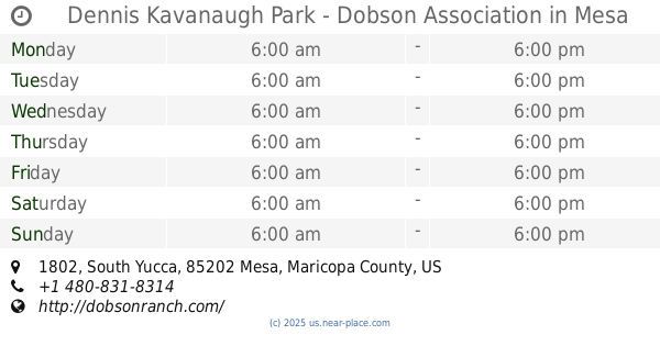
Dennis Kavanaugh Park - Dobson Association
1802 South Yucca, Mesa
Park
read more
3.434 km
Stapley Park
360 South Lesueur, Mesa
Park
read more
3.693 km
Mesa Urban Garden
212 East 1st Avenue, Mesa
Park
read more
3.855 km
Lds
Mesa Arizona Temple The Church of Jesus Christ of Latter-day Saints,, South Lesueur, Mesa
Park
read more
3.92 km
Gateway Park
315 East Main Street, Mesa
Park
read more
3.944 km
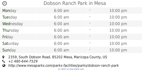
Dobson Ranch Park
2359 South Dobson Road, Mesa
Park
read more
3.982 km
McAfee Place Unit Two Mini Park
Mesa
Park
read more
4.06 km
Ehrhardt Park
4003 South Evergreen Road, Tempe
Park
read more
4.283 km
Pioneer Park
526 East Main Street, Mesa
Park
read more
4.587 km
The Wright House
636 West University Drive, Mesa
Park
read more
4.764 km
Washington Park
44 East 5th Street, Mesa
Park
read more
4.877 km
Vista Allegre Park
Gilbert
Park
read more
4.956 km
Escobedo Park
215 East 6th Street, Mesa
Park
read more
5.206 km
Rocket Park
Mesa
Park
read more
5.601 km
Walking Path, Gilbert
133 North Gilbert Road, Gilbert
Park
read more
5.933 km
Esquer Park
2407 East McArthur Drive, Tempe
Park
read more
📑
all categories
Accounting
Administrative area level 1
Administrative area level 2
Airport
Amusement park
Aquarium
Art gallery
Atm
Bakery
Bank
Bar
Beauty salon
Bicycle store
Book store
Bowling alley
Bus station
Cafe
Campground
Car dealer
Car rental
Car repair
Car wash
Casino
Cemetery
Church
City hall
Clothing store
Colloquial area
Convenience store
Courthouse
Dentist
Department store
Doctor
Electrician
Electronics store
Embassy
Establishment
Finance
Fire station
Florist
Food
Funeral home
Furniture store
Gas station
General contractor
Grocery or supermarket
Gym
Hair care
Hardware store
Health
Hindu Temple
Home goods store
Hospital
Insurance agency
Intersection
Jewelry store
Laundry
Lawyer
Library
Light rail station
Liquor store
Local government office
Locality
Locksmith
Lodging
Meal delivery
Meal takeaway
Mosque
Movie rental
Movie theater
Moving company
Museum
Natural feature
Neighborhood
Night club
Painter
Park
Parking
Pet store
Pharmacy
Physiotherapist
Place of worship
Plumber
Point of interest
Police
Political
Post office
Premise
Real estate agency
Restaurant
Roofing contractor
Route
Rv park, camping
School
Shoe store
Shopping mall
Spa
Stadium
Storage
Store
Subpremise
Subway station
Supermarket
Synagogue
Taxi stand
Train station
Transit station
Travel agency
University
Veterinary care
Zoo
administrative area level 3
sublocality level 1
↑