Park nearby Esquer Park
Coronavirus disease (COVID-19) Situation
confirmed cases
111820082
deaths
1219487
United States
Park nearby Esquer Park
Esquer Park
2407 East McArthur Drive, Tempe United States
contacts phone
:
+1
Latitude:
33.4162438
, Longitude:
-111.8875999
read more
nearest Park
627 m
Carpenter's Son Custom Garden Planters
811 South George Drive, Tempe
Park
read more
717 m
Escalalante Community Center
2150 East Orange Street, Tempe
Park
read more
781 m
Escalante Community Garden
2150 East Orange Street, Tempe
Park
read more
800 m
Escalante Park
2150 East Orange Street, Tempe
Park
read more
1.369 km
Alegre Park
1940 East Don Carlos Avenue, Tempe
Park
read more
1.545 km
Peter's Organic World
1949 East University Drive #209, Tempe
Park
read more
1.611 km
Connolly Field
Tempe
Park
read more
1.927 km
Daumler Park
2821 South Evergreen Road, Tempe
Park
read more
1.996 km
Tempe Basketball Court
Tempe
Park
read more
2.068 km
Selleh Park
2425 South Los Feliz Drive, Tempe
Park
read more
2.16 km
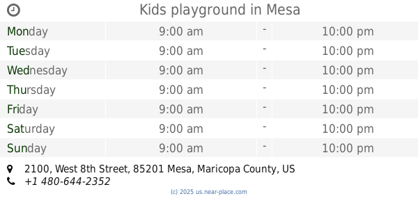
Kids playground
2100 West 8th Street, Mesa
Park
read more
2.241 km
Riverview Park
2100 West Rio Salado Parkway, Mesa
Park
read more
2.389 km
Salt River Walking Path
Mesa
Park
read more
3.301 km
Ehrhardt Park
4003 South Evergreen Road, Tempe
Park
read more
3.63 km
Riverview Park
1130-1150 North Alma School Road, Mesa
Park
read more
3.692 km
Barrett Great Courtyard
Tempe
Park
read more
3.821 km
Kleinman Park
710 South Extension Road, Mesa
Park
read more
3.918 km
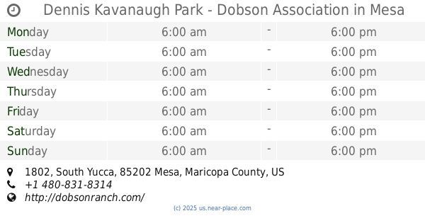
Dennis Kavanaugh Park - Dobson Association
1802 South Yucca, Mesa
Park
read more
4.225 km
Daley Park
1625 South College Avenue, Tempe
Park
read more
4.527 km
ASU Herb Garden
201 Orange Mall, Tempe
Park
read more
4.802 km
Papago Bark Park
Tempe
Park
read more
5.013 km
Giuliano Park
80 East Rio Salado Parkway, Tempe
Park
read more
5.109 km
Guerrero Rotary Park
205 West 8th Avenue, Mesa
Park
read more
5.736 km
Evelyn Hallman Park
1900 North College Avenue, Tempe
Park
read more
5.937 km
Crosscut Canal Path
Crosscut Canal Multi-use Path, Tempe
Park
read more
📑
all categories
Accounting
Administrative area level 1
Administrative area level 2
Airport
Amusement park
Aquarium
Art gallery
Atm
Bakery
Bank
Bar
Beauty salon
Bicycle store
Book store
Bowling alley
Bus station
Cafe
Campground
Car dealer
Car rental
Car repair
Car wash
Casino
Cemetery
Church
City hall
Clothing store
Colloquial area
Convenience store
Courthouse
Dentist
Department store
Doctor
Electrician
Electronics store
Embassy
Establishment
Finance
Fire station
Florist
Food
Funeral home
Furniture store
Gas station
General contractor
Grocery or supermarket
Gym
Hair care
Hardware store
Health
Hindu Temple
Home goods store
Hospital
Insurance agency
Intersection
Jewelry store
Laundry
Lawyer
Library
Light rail station
Liquor store
Local government office
Locality
Locksmith
Lodging
Meal delivery
Meal takeaway
Mosque
Movie rental
Movie theater
Moving company
Museum
Natural feature
Neighborhood
Night club
Painter
Park
Parking
Pet store
Pharmacy
Physiotherapist
Place of worship
Plumber
Point of interest
Police
Political
Post office
Premise
Real estate agency
Restaurant
Roofing contractor
Route
Rv park, camping
School
Shoe store
Shopping mall
Spa
Stadium
Storage
Store
Subpremise
Subway station
Supermarket
Synagogue
Taxi stand
Train station
Transit station
Travel agency
University
Veterinary care
Zoo
administrative area level 3
sublocality level 1
↑