Dentist nearby Chong Michael L DDS
United States
Dentist nearby Chong Michael L DDS
Chong Michael L DDS
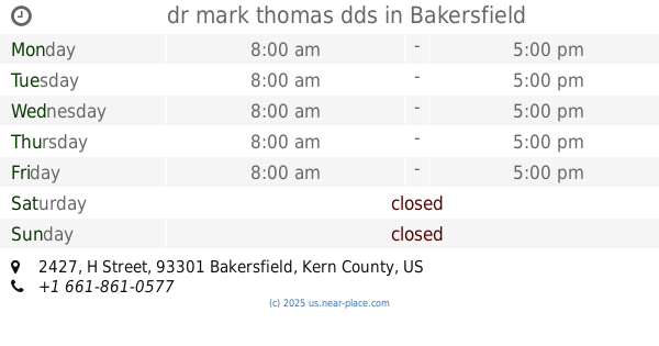
1430 Truxtun Avenue, Bakersfield United States
contacts phone
:
+1
Latitude:
35.3736805
, Longitude:
-119.0180719
read more
nearest Dentist
21 m
Magallanes Elizabeth DDS
1430 Truxtun Avenue #400, Bakersfield
Dentist
read more
58 m
Dr. Julio Mendoza, DDS
1430 Truxtun Avenue, Bakersfield
Dentist
read more
591 m
Song Hi-Tech Dental Lab
1920 F Street, Bakersfield
Dentist
read more
623 m
Landmark Dental Downtown
2200 Chester Avenue, Bakersfield
Dentist
Health
Point of interest
Establishment
read more
625 m
Dr. John Postgate
2200 Chester Avenue, Bakersfield
Dentist
Health
Point of interest
Establishment
read more
625 m
Mahdi Anmar DDS
2200 Chester Avenue, Bakersfield
Dentist
Point of interest
Health
Establishment
read more
785 m
Dr. Madhuri Kothapalli, DDS
1201 24th Street, Bakersfield
Dentist
Health
Point of interest
Establishment
read more
785 m
Western Dental & Orthodontics
1201 24th Street, Bakersfield
Dentist
Doctor
Point of interest
Health
Establishment
read more
794 m
Attia Hany a DDS
1201 24th Street A, Bakersfield
Dentist
Health
Point of interest
Establishment
read more
813 m
Chau Fouy K DDS
1201 24th Street, Bakersfield
Dentist
Point of interest
Health
Establishment
read more
867 m
Jim Peyton, DDS
2212 Truxtun Avenue, Bakersfield
Dentist
Health
Point of interest
Establishment
read more
958 m
dr mark thomas dds
2427 H Street A, Bakersfield
Dentist
Health
Point of interest
Establishment
read more
974 m
Dedicated Dental
2415 G Street, Bakersfield
Dentist
Health
Point of interest
Establishment
read more
997 m
Thomas-Pugh Brenda L DDS
2525 Eye Street # A, Bakersfield
Dentist
Health
Point of interest
Establishment
read more
997 m
Schuler Stanton E DDS
2525 Eye Street # 100, Bakersfield
Dentist
Health
Point of interest
Establishment
read more
📑
all categories
Accounting
Administrative area level 1
Administrative area level 2
Airport
Amusement park
Aquarium
Art gallery
Atm
Bakery
Bank
Bar
Beauty salon
Bicycle store
Book store
Bowling alley
Bus station
Cafe
Campground
Car dealer
Car rental
Car repair
Car wash
Casino
Cemetery
Church
City hall
Clothing store
Colloquial area
Convenience store
Courthouse
Dentist
Department store
Doctor
Electrician
Electronics store
Embassy
Establishment
Finance
Fire station
Florist
Food
Funeral home
Furniture store
Gas station
General contractor
Grocery or supermarket
Gym
Hair care
Hardware store
Health
Hindu Temple
Home goods store
Hospital
Insurance agency
Intersection
Jewelry store
Laundry
Lawyer
Library
Light rail station
Liquor store
Local government office
Locality
Locksmith
Lodging
Meal delivery
Meal takeaway
Mosque
Movie rental
Movie theater
Moving company
Museum
Natural feature
Neighborhood
Night club
Painter
Park
Parking
Pet store
Pharmacy
Physiotherapist
Place of worship
Plumber
Point of interest
Police
Political
Post office
Premise
Real estate agency
Restaurant
Roofing contractor
Route
Rv park, camping
School
Shoe store
Shopping mall
Spa
Stadium
Storage
Store
Subpremise
Subway station
Supermarket
Synagogue
Taxi stand
Train station
Transit station
Travel agency
University
Veterinary care
Zoo
administrative area level 3
sublocality level 1
↑