Convenience store nearby Rite Aid
Coronavirus disease (COVID-19) Situation
confirmed cases
111820082
deaths
1219487
United States
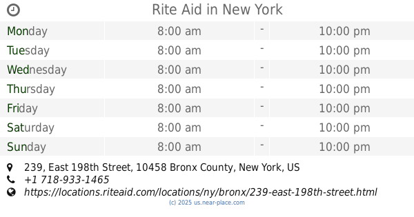
Convenience store nearby Rite Aid
Rite Aid
3480, Jerome Avenue, 10467, Bronx County, New York, US Соединенные Штаты Америки
contacts phone
:
+1 718-231-2609
website:
locations.riteaid.com
Latitude:
40.882053
, Longitude:
-73.8814822
larger map & directions
read more
nearest Convenience store
62 m
Sala Candy
16 East Gun Hill Road, Bronx
Convenience store
read more
323 m
Marte Venecia M
3400 Bainbridge Avenue, Bronx
Convenience store
read more
416 m
Jerome Convenient
3598 Jerome Avenue, Bronx
Convenience store
read more
428 m
Hernandez Food & Meat Market
215 East Gun Hill Road, Bronx
Convenience store
read more
746 m
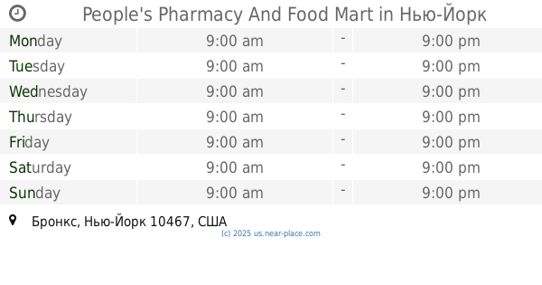
People's Pharmacy And Food Mart
Bronx
Convenience store
read more
823 m
Bainbridge Candy & Gifts
3138 Bainbridge Avenue, Bronx
Convenience store
read more
862 m
CVS
3125 Bainbridge Avenue, Bronx
Convenience store
read more
1.186 km
A a Deli
361 East 204th Street, Bronx
Convenience store
read more
1.2 km
Quick Stop
2 Bedford Park Boulevard, Bronx
Convenience store
read more
1.548 km
Rite Aid
239 East 198th Street, Bronx
Convenience store
read more
1.669 km
Rite Aid
5825-35 Broadway, Bronx
Convenience store
read more
1.981 km
3925 Yanery Groceries Inc
3925 Barnes Avenue, Bronx
Convenience store
read more
2.159 km
AM General Store
7301, 685A Allerton Avenue, Bronx
Convenience store
read more
2.16 km
Allerton Candy and Grocery Store
685 Allerton Avenue, Bronx
Convenience store
read more
2.351 km
Alanis Deli Grocery Corp.
2565 Grand Concourse, Bronx
Convenience store
read more
📑
all categories
Accounting
Administrative area level 1
Administrative area level 2
Airport
Amusement park
Aquarium
Art gallery
Atm
Bakery
Bank
Bar
Beauty salon
Bicycle store
Book store
Bowling alley
Bus station
Cafe
Campground
Car dealer
Car rental
Car repair
Car wash
Casino
Cemetery
Church
City hall
Clothing store
Colloquial area
Convenience store
Courthouse
Dentist
Department store
Doctor
Electrician
Electronics store
Embassy
Establishment
Finance
Fire station
Florist
Food
Funeral home
Furniture store
Gas station
General contractor
Grocery or supermarket
Gym
Hair care
Hardware store
Health
Hindu Temple
Home goods store
Hospital
Insurance agency
Intersection
Jewelry store
Laundry
Lawyer
Library
Light rail station
Liquor store
Local government office
Locality
Locksmith
Lodging
Meal delivery
Meal takeaway
Mosque
Movie rental
Movie theater
Moving company
Museum
Natural feature
Neighborhood
Night club
Painter
Park
Parking
Pet store
Pharmacy
Physiotherapist
Place of worship
Plumber
Point of interest
Police
Political
Post office
Premise
Real estate agency
Restaurant
Roofing contractor
Route
Rv park, camping
School
Shoe store
Shopping mall
Spa
Stadium
Storage
Store
Subpremise
Subway station
Supermarket
Synagogue
Taxi stand
Train station
Transit station
Travel agency
University
Veterinary care
Zoo
administrative area level 3
sublocality level 1
↑