Bar nearby Tooey's, off colfax
Coronavirus disease (COVID-19) Situation
confirmed cases
111820082
deaths
1219487
United States
Bar nearby Tooey's, off colfax
Tooey's, off colfax
1521 North Marion Street, Denver Stany Zjednoczone
contacts phone
:
+1
Latitude:
39.7404866
, Longitude:
-104.9723738
read more
nearest Bar
29 m
Kinga's Lounge
1509 North Marion Street, Denver
Bar
read more
69 m
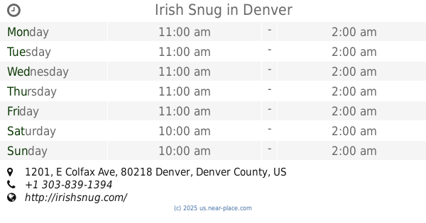
Irish Snug
1201 E Colfax Ave #100, Denver
Bar
read more
81 m
Wood River Restaurant and Bar
1150 East Colfax Avenue, Denver
Bar
read more
291 m
Blush & Blu
1526 East Colfax Avenue, Denver
Bar
read more
351 m
Mile High Hamburger Mary's
1336 East 17th Avenue, Denver
Bar
read more
352 m
Stoney's Uptown Joint
1035 East 17th Avenue, Denver
Bar
read more
380 m
QDOBA Mexican Eats
1400 East 17th Avenue Ste D, Denver
Bar
read more
459 m
Sancho's Broken Arrow
741 East Colfax Avenue, Denver
Bar
read more
468 m
Next Door Lounge
1612 East 17th Avenue, Denver
Bar
read more
492 m
The 1up - Colfax
717 East Colfax Avenue, Denver
Bar
read more
535 m
Slice Works
700 East Colfax Avenue, Denver
Bar
read more
541 m
Here At Kristines
1440 North Washington Street, Denver
Bar
read more
568 m
X BAR
629 East Colfax Avenue, Denver
Bar
read more
630 m
The Avenue Grill
630 East 17th Avenue, Denver
Bar
read more
730 m
Prohibition
504 East Colfax Avenue, Denver
Bar
read more
734 m
Pearl’s
608 East 13th Avenue, Denver
Bar
read more
760 m
Potager
1109 North Ogden Street, Denver
Bar
read more
828 m
Pride and Swagger
450 East 17th Avenue #110, Denver
Bar
read more
892 m
Be On Key Psychedelic Ripple
1700 Logan Street, Denver
Bar
read more
896 m
city grille
321 East Colfax Avenue, Denver
Bar
read more
938 m
Retrograde
530 East 19th Avenue, Denver
Bar
read more
947 m
Vine Street Pub & Brewery
1700 Vine Street, Denver
Bar
read more
1.009 km
Bender's Tavern
314 East 13th Avenue, Denver
Bar
read more
1.02 km
Randolph's Restaurant & Bar
1776 Grant Street, Denver
Bar
read more
1.333 km
Charlie Brown's
980 Grant Street, Denver
Bar
read more
📑
all categories
Accounting
Administrative area level 1
Administrative area level 2
Airport
Amusement park
Aquarium
Art gallery
Atm
Bakery
Bank
Bar
Beauty salon
Bicycle store
Book store
Bowling alley
Bus station
Cafe
Campground
Car dealer
Car rental
Car repair
Car wash
Casino
Cemetery
Church
City hall
Clothing store
Colloquial area
Convenience store
Courthouse
Dentist
Department store
Doctor
Electrician
Electronics store
Embassy
Establishment
Finance
Fire station
Florist
Food
Funeral home
Furniture store
Gas station
General contractor
Grocery or supermarket
Gym
Hair care
Hardware store
Health
Hindu Temple
Home goods store
Hospital
Insurance agency
Intersection
Jewelry store
Laundry
Lawyer
Library
Light rail station
Liquor store
Local government office
Locality
Locksmith
Lodging
Meal delivery
Meal takeaway
Mosque
Movie rental
Movie theater
Moving company
Museum
Natural feature
Neighborhood
Night club
Painter
Park
Parking
Pet store
Pharmacy
Physiotherapist
Place of worship
Plumber
Point of interest
Police
Political
Post office
Premise
Real estate agency
Restaurant
Roofing contractor
Route
Rv park, camping
School
Shoe store
Shopping mall
Spa
Stadium
Storage
Store
Subpremise
Subway station
Supermarket
Synagogue
Taxi stand
Train station
Transit station
Travel agency
University
Veterinary care
Zoo
administrative area level 3
sublocality level 1
↑