Bar nearby The Firehouse 5
Coronavirus disease (COVID-19) Situation
confirmed cases
111820082
deaths
1219487
United States
Bar nearby The Firehouse 5
The Firehouse 5
2014 9th Street, Sacramento United States
contacts phone
:
+1
Latitude:
38.5692836
, Longitude:
-121.4999938
read more
nearest Bar
309 m
Elixir
1815 10th Street, Sacramento
Bar
read more
367 m
Fox & Goose Public House
1001 R Street, Sacramento
Bar
read more
462 m
Bottle & Barlow
1120 R St, Sacramento
Bar
read more
671 m
Urban Roots Brewery & Smokehouse
1322 V Street, Sacramento
Bar
read more
749 m
The Shady Lady Saloon
1409 R Street, Sacramento
Bar
read more
762 m
Jamie's Bar & Grill
427 Broadway, Sacramento
Bar
read more
763 m
Iron steaks, seafood, chicken, salads Grill
2422 13th Street, Sacramento
Bar
read more
763 m
Iron Grill
2422 13th Street, Sacramento
Bar
read more
775 m
Burgers and Brew
1409 R St #105, Sacramento
Bar
read more
778 m
B-Side
1430 S Street, Sacramento
Bar
read more
794 m
Mas Taco Bar
1800 15th Street suite d, Sacramento
Bar
read more
830 m
R15
1431 R Street, Sacramento
Bar
read more
903 m
Flame Club
2130 16th Street, Sacramento
Bar
read more
918 m
X-O Lounge
1400 Broadway, Sacramento
Bar
read more
982 m
Sampino’s Kitchen at Joe Marty’s
1500 Broadway, Sacramento
Bar
read more
982 m
Joe Marty's Bar & Grille
1500 Broadway, Sacramento
Bar
read more
1.011 km
Hook and Ladder Manufacturing Company
1630 S Street, Sacramento
Bar
read more
1.068 km
Supper Club
216 O Street, Sacramento
Bar
read more
1.197 km
Simon Chan Restaurant
1415 16th Street, Sacramento
Bar
read more
1.2 km
Ruhstaller BSMT [ opening soon ]
726 K Street, Sacramento
Bar
read more
1.298 km
Ten Ten Room
1010 10th Street, Sacramento
Bar
read more
1.413 km
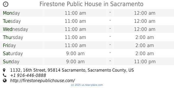
Firestone Public House
1132 16th Street, Sacramento
Bar
read more
1.437 km
O'Mally's Irish Pub
1109 2nd Street, Sacramento
Bar
read more
1.624 km
Torch Club
904 15th Street, Sacramento
Bar
read more
1.629 km
Outdoor Bar - Very New
1830 L Street, Sacramento
Bar
read more
📑
all categories
Accounting
Administrative area level 1
Administrative area level 2
Airport
Amusement park
Aquarium
Art gallery
Atm
Bakery
Bank
Bar
Beauty salon
Bicycle store
Book store
Bowling alley
Bus station
Cafe
Campground
Car dealer
Car rental
Car repair
Car wash
Casino
Cemetery
Church
City hall
Clothing store
Colloquial area
Convenience store
Courthouse
Dentist
Department store
Doctor
Electrician
Electronics store
Embassy
Establishment
Finance
Fire station
Florist
Food
Funeral home
Furniture store
Gas station
General contractor
Grocery or supermarket
Gym
Hair care
Hardware store
Health
Hindu Temple
Home goods store
Hospital
Insurance agency
Intersection
Jewelry store
Laundry
Lawyer
Library
Light rail station
Liquor store
Local government office
Locality
Locksmith
Lodging
Meal delivery
Meal takeaway
Mosque
Movie rental
Movie theater
Moving company
Museum
Natural feature
Neighborhood
Night club
Painter
Park
Parking
Pet store
Pharmacy
Physiotherapist
Place of worship
Plumber
Point of interest
Police
Political
Post office
Premise
Real estate agency
Restaurant
Roofing contractor
Route
Rv park, camping
School
Shoe store
Shopping mall
Spa
Stadium
Storage
Store
Subpremise
Subway station
Supermarket
Synagogue
Taxi stand
Train station
Transit station
Travel agency
University
Veterinary care
Zoo
administrative area level 3
sublocality level 1
↑