Bar nearby Planet Rose
Coronavirus disease (COVID-19) Situation
confirmed cases
111820082
deaths
1219487
United States
Bar nearby Planet Rose
Planet Rose
219, Avenue A, 10009, New York, New York County, US United States
contacts phone
:
+1 212-353-9500
website:
www.planetrosenyc.com
Latitude:
40.7301415
, Longitude:
-73.9807172
larger map & directions
read more
nearest Bar
188 m
Otto's Shrunken Head
538 East 14th Street, New York
Bar
read more
251 m
Flinders Lane
162 Avenue A, New York
Bar
read more
433 m
The Hard Swallow (Big Lee's)
140 1st Avenue, New York
Bar
read more
437 m
Pangea
178 2nd Avenue, New York
Bar
read more
450 m
The Woodstock
446 East 14th Street, New York
Bar
read more
519 m
Ravagh
125 1st Avenue, New York
Bar
read more
575 m
Amor y Amargo
443 East 6th Street, New York
Bar
read more
647 m
upstate craft beer & oyster bar
95 1st Avenue, New York
Bar
read more
670 m
Brazen Fox
106 3rd Avenue, New York
Bar
read more
752 m
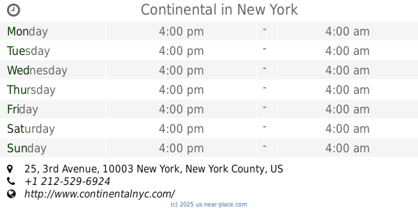
Continental
25 3rd Avenue, New York
Bar
read more
801 m
Fish Bar
237 East 5th Street, New York
Bar
read more
827 m
Ichabod's
15 Irving Place, New York
Bar
read more
844 m
McSwiggan's
393 2nd Avenue, New York
Bar
read more
901 m
d.b.a.
41 1st Avenue, New York
Bar
read more
1.005 km
B Bar & Grill
40 E 4th St, New York
Bar
read more
1.069 km
Vapiano NYC
113 University Place, New York
Bar
read more
1.094 km
Old Town Bar
45 East 18th Street, New York
Bar
read more
1.128 km
Barn Joo
35 Union Square West, New York
Bar
read more
1.158 km
Bob Bar
235 Eldridge Street, New York
Bar
read more
1.177 km
Arlene's Grocery
95 Stanton Street, New York
Bar
read more
1.238 km
The Cellar
900 Broadway, New York
Bar
read more
1.295 km
Bonnie Vee
17 Stanton Street, New York
Bar
read more
1.312 km
Office In A Box
195 Chrystie Street, New York
Bar
read more
1.326 km
et al.
191 Chrystie Street, New York
Bar
read more
1.344 km
Freemans
Freeman Alley, New York
Bar
read more
📑
all categories
Accounting
Administrative area level 1
Administrative area level 2
Airport
Amusement park
Aquarium
Art gallery
Atm
Bakery
Bank
Bar
Beauty salon
Bicycle store
Book store
Bowling alley
Bus station
Cafe
Campground
Car dealer
Car rental
Car repair
Car wash
Casino
Cemetery
Church
City hall
Clothing store
Colloquial area
Convenience store
Courthouse
Dentist
Department store
Doctor
Electrician
Electronics store
Embassy
Establishment
Finance
Fire station
Florist
Food
Funeral home
Furniture store
Gas station
General contractor
Grocery or supermarket
Gym
Hair care
Hardware store
Health
Hindu Temple
Home goods store
Hospital
Insurance agency
Intersection
Jewelry store
Laundry
Lawyer
Library
Light rail station
Liquor store
Local government office
Locality
Locksmith
Lodging
Meal delivery
Meal takeaway
Mosque
Movie rental
Movie theater
Moving company
Museum
Natural feature
Neighborhood
Night club
Painter
Park
Parking
Pet store
Pharmacy
Physiotherapist
Place of worship
Plumber
Point of interest
Police
Political
Post office
Premise
Real estate agency
Restaurant
Roofing contractor
Route
Rv park, camping
School
Shoe store
Shopping mall
Spa
Stadium
Storage
Store
Subpremise
Subway station
Supermarket
Synagogue
Taxi stand
Train station
Transit station
Travel agency
University
Veterinary care
Zoo
administrative area level 3
sublocality level 1
↑