Bar nearby Churchill's
Coronavirus disease (COVID-19) Situation
confirmed cases
111820082
deaths
1219487
United States
Bar nearby Churchill's
Churchill's
321 17th Street, Denver Stany Zjednoczone
contacts phone
:
+1
Latitude:
39.74391
, Longitude:
-104.987661
read more
nearest Bar
193 m
Yard House
1555 Court Pl, Denver
Bar
read more
250 m
Shelby's Bar & Grill
519 18th Street, Denver
Bar
read more
362 m
Otra Vez Cantina
610 16th Street, Denver
Bar
read more
486 m
Be On Key Psychedelic Ripple
1700 Logan Street, Denver
Bar
read more
530 m
54thirty
1475 California Street, Denver
Bar
read more
572 m
Soko Sushi & Saki Bar
1600 Champa st #200, Denver
Bar
read more
611 m
W Xyz Lounge
800 15th Street, Denver
Bar
read more
615 m
Elements
1420 Stout Street, 4th Floor, Denver
Bar
read more
634 m
Stout Street Social
1400 Stout Street, Denver
Bar
read more
649 m
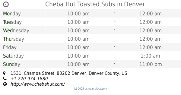
Cheba Hut Toasted Subs
1531 Champa Street, Denver
Bar
read more
677 m
Rialto Cafe
934 16th Street, Denver
Bar
read more
736 m
Prohibition
504 East Colfax Avenue, Denver
Bar
read more
753 m
The Avenue Grill
630 East 17th Avenue, Denver
Bar
read more
845 m
X BAR
629 East Colfax Avenue, Denver
Bar
read more
880 m
Bender's Tavern
314 East 13th Avenue, Denver
Bar
read more
888 m
Cap City Tavern
1247 Bannock Street, Denver
Bar
read more
918 m
The 1up - Colfax
717 East Colfax Avenue, Denver
Bar
read more
949 m
The Old Spaghetti Factory
1215 18th Street, Denver
Bar
read more
970 m
Blue Agave Grill
1201 16th Street #104, Denver
Bar
read more
987 m
Front Porch
1215 15th Street, Denver
Bar
read more
1.055 km
Pearl’s
608 East 13th Avenue, Denver
Bar
read more
1.076 km
Shopping on Larimer Square
14th Street, Denver
Bar
read more
1.102 km
Oskar Blues Grill & Brew - Denver
1624 Market Street, Denver
Bar
read more
1.128 km
Lamark 15
1322 15th Street, Denver
Bar
read more
1.227 km
Denver Pony
1301 Santa Fe Drive, Denver
Bar
read more
📑
all categories
Accounting
Administrative area level 1
Administrative area level 2
Airport
Amusement park
Aquarium
Art gallery
Atm
Bakery
Bank
Bar
Beauty salon
Bicycle store
Book store
Bowling alley
Bus station
Cafe
Campground
Car dealer
Car rental
Car repair
Car wash
Casino
Cemetery
Church
City hall
Clothing store
Colloquial area
Convenience store
Courthouse
Dentist
Department store
Doctor
Electrician
Electronics store
Embassy
Establishment
Finance
Fire station
Florist
Food
Funeral home
Furniture store
Gas station
General contractor
Grocery or supermarket
Gym
Hair care
Hardware store
Health
Hindu Temple
Home goods store
Hospital
Insurance agency
Intersection
Jewelry store
Laundry
Lawyer
Library
Light rail station
Liquor store
Local government office
Locality
Locksmith
Lodging
Meal delivery
Meal takeaway
Mosque
Movie rental
Movie theater
Moving company
Museum
Natural feature
Neighborhood
Night club
Painter
Park
Parking
Pet store
Pharmacy
Physiotherapist
Place of worship
Plumber
Point of interest
Police
Political
Post office
Premise
Real estate agency
Restaurant
Roofing contractor
Route
Rv park, camping
School
Shoe store
Shopping mall
Spa
Stadium
Storage
Store
Subpremise
Subway station
Supermarket
Synagogue
Taxi stand
Train station
Transit station
Travel agency
University
Veterinary care
Zoo
administrative area level 3
sublocality level 1
↑