University nearby Mesa Community College - PAC
United States
University nearby Mesa Community College - PAC
Mesa Community College - PAC
1520 South Longmore, Mesa United States
contacts phone
:
+1
Latitude:
33.3874235
, Longitude:
-111.865494
read more
nearest University
70 m
MCC Performing Arts Center
1520 South Longmore, Mesa
University
read more
717 m
Mesa Community College
1833 West Southern Avenue, Mesa
University
read more
805 m
Dept of Physical Science
1833 West Southern Avenue, Mesa
University
read more
841 m
NAU at Mesa Community College
1833 West Southern Avenue Building #38, Mesa
University
read more
1.006 km
DeVry University
1201 South Alma School Road #5450, Mesa
University
read more
1.012 km
Debra Johnson, PNP: Pediatric Nurse Practitioner
1432 South Dobson Road, Mesa
University
read more
1.02 km
Keller Graduate School of Management- Mesa Center
1201 South Alma School Road Suite 5450, Mesa
University
read more
1.107 km
Renae Merz, ACPNP: Pediatric Nurse Practitioner
1400 South Dobson Road, Mesa
University
read more
1.27 km
Carrington College
1001 West Southern Avenue #130, Mesa
University
read more
1.323 km
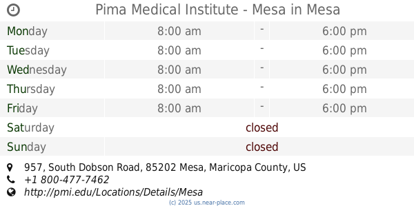
Pima Medical Institute - Mesa
957 South Dobson Road, Mesa
University
read more
2.274 km
Apollo College-Tri City
1322 South Country Club Drive, Mesa
University
read more
2.679 km
Rio Salad College Southern Testing Center
3320 South Price Road, Tempe
University
read more
2.689 km
Rio Salado College East Valley
3320 South Price Road, Tempe
University
read more
2.838 km
East Valley Institute of Technology (EVIT)
1601 West Main Street, Mesa
University
read more
3.507 km
Southwest College of Naturopathic Medicine
2140 East Broadway Road, Tempe
University
read more
📑
all categories
Accounting
Administrative area level 1
Administrative area level 2
Airport
Amusement park
Aquarium
Art gallery
Atm
Bakery
Bank
Bar
Beauty salon
Bicycle store
Book store
Bowling alley
Bus station
Cafe
Campground
Car dealer
Car rental
Car repair
Car wash
Casino
Cemetery
Church
City hall
Clothing store
Colloquial area
Convenience store
Courthouse
Dentist
Department store
Doctor
Electrician
Electronics store
Embassy
Establishment
Finance
Fire station
Florist
Food
Funeral home
Furniture store
Gas station
General contractor
Grocery or supermarket
Gym
Hair care
Hardware store
Health
Hindu Temple
Home goods store
Hospital
Insurance agency
Intersection
Jewelry store
Laundry
Lawyer
Library
Light rail station
Liquor store
Local government office
Locality
Locksmith
Lodging
Meal delivery
Meal takeaway
Mosque
Movie rental
Movie theater
Moving company
Museum
Natural feature
Neighborhood
Night club
Painter
Park
Parking
Pet store
Pharmacy
Physiotherapist
Place of worship
Plumber
Point of interest
Police
Political
Post office
Premise
Real estate agency
Restaurant
Roofing contractor
Route
Rv park, camping
School
Shoe store
Shopping mall
Spa
Stadium
Storage
Store
Subpremise
Subway station
Supermarket
Synagogue
Taxi stand
Train station
Transit station
Travel agency
University
Veterinary care
Zoo
administrative area level 3
sublocality level 1
↑