Store nearby Target Grocery
United States
Store nearby Target Grocery
Target Grocery
2901, Ming Avenue, 93304, Bakersfield, Kern County, US United States
contacts phone
:
+1 661-617-2000
website:
www.target.com
Latitude:
35.3366577
, Longitude:
-119.0359914
larger map & directions
read more
nearest Store
16 m
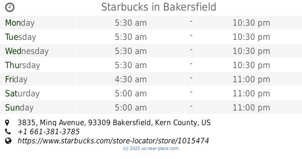
Starbucks
2901 Ming Avenue, Bakersfield
Cafe
Food
Point of interest
Store
Establishment
read more
161 m
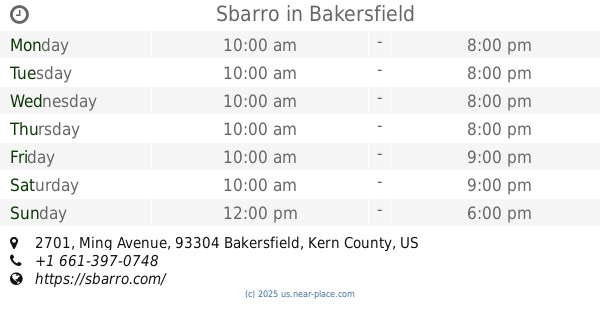
Sbarro
2701 Ming Avenue #402, Bakersfield
Meal delivery
Meal takeaway
Restaurant
Store
Point of interest
Food
Establishment
read more
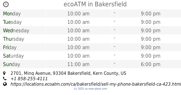
167 m
ecoATM
2701 Ming Avenue, Bakersfield
Atm
Finance
Point of interest
Store
Establishment
read more
296 m
Starbucks
2701 Ming Avenue, Bakersfield
Cafe
Food
Store
Point of interest
Establishment
read more
761 m
Fastrip
3701 Ming Avenue, Bakersfield
Convenience store
Gas station
Atm
Liquor store
Food
Store
Point of interest
Finance
Establishment
read more
994 m
Starbucks
3835 Ming Avenue, Bakersfield
Cafe
Restaurant
Food
Store
Point of interest
Establishment
read more
1.457 km
FoodMaxx
4470 Ming Avenue, Bakersfield
Supermarket
Grocery or supermarket
Food
Store
Point of interest
Establishment
read more
1.64 km
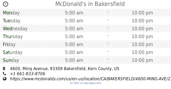
McDonald's
4600 Ming Avenue, Bakersfield
Cafe
Restaurant
Food
Point of interest
Store
Establishment
read more
1.664 km
Snappy Food Store
1700 South Chester Avenue, Bakersfield
Convenience store
Atm
Finance
Food
Store
Point of interest
Establishment
read more
1.965 km
Family Dollar
2219 Brundage Lane, Bakersfield
Clothing store
Supermarket
Grocery or supermarket
Food
Store
Point of interest
Establishment
read more
2.392 km
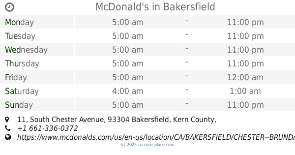
McDonald's
11 South Chester Avenue, Bakersfield
Cafe
Restaurant
Food
Point of interest
Store
Establishment
read more
2.393 km
Dutch Bros Coffee
15 South Chester Avenue, Bakersfield
Cafe
Food
Point of interest
Store
Establishment
read more
2.466 km
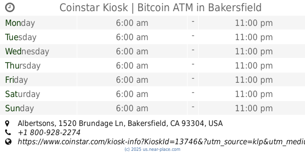
Coinstar Kiosk | Bitcoin ATM
Albertsons, 1520 Brundage Ln, Bakersfield
Atm
Finance
Store
Point of interest
Establishment
read more
2.768 km
Starbucks
5101 Stockdale Highway, Bakersfield
Cafe
Restaurant
Food
Store
Point of interest
Establishment
read more
3.163 km
Foster's Donuts
5620 California Avenue D, Bakersfield
Bakery
Cafe
Restaurant
Food
Store
Point of interest
Establishment
read more
📑
all categories
Accounting
Administrative area level 1
Administrative area level 2
Airport
Amusement park
Aquarium
Art gallery
Atm
Bakery
Bank
Bar
Beauty salon
Bicycle store
Book store
Bowling alley
Bus station
Cafe
Campground
Car dealer
Car rental
Car repair
Car wash
Casino
Cemetery
Church
City hall
Clothing store
Colloquial area
Convenience store
Courthouse
Dentist
Department store
Doctor
Electrician
Electronics store
Embassy
Establishment
Finance
Fire station
Florist
Food
Funeral home
Furniture store
Gas station
General contractor
Grocery or supermarket
Gym
Hair care
Hardware store
Health
Hindu Temple
Home goods store
Hospital
Insurance agency
Intersection
Jewelry store
Laundry
Lawyer
Library
Light rail station
Liquor store
Local government office
Locality
Locksmith
Lodging
Meal delivery
Meal takeaway
Mosque
Movie rental
Movie theater
Moving company
Museum
Natural feature
Neighborhood
Night club
Painter
Park
Parking
Pet store
Pharmacy
Physiotherapist
Place of worship
Plumber
Point of interest
Police
Political
Post office
Premise
Real estate agency
Restaurant
Roofing contractor
Route
Rv park, camping
School
Shoe store
Shopping mall
Spa
Stadium
Storage
Store
Subpremise
Subway station
Supermarket
Synagogue
Taxi stand
Train station
Transit station
Travel agency
University
Veterinary care
Zoo
administrative area level 3
sublocality level 1
↑