Park nearby Индиан Брук Фолс
United States
Park nearby Индиан Брук Фолс
Индиан Брук Фолс
Garrison, NY 10524, США
contacts phone
:
+1
Latitude:
41.4049635
, Longitude:
-73.9291638
larger map & directions
read more
nearest Park
Indian Brook Falls
Garrison
Park
read more
837 m
Constitution Marsh Audubon Center and Sanctuary
127 Warren Landing Road, Garrison
Park
read more
1.176 km
Boscobel House and Gardens
1601 New York 9D, Garrison
Park
read more
1.677 km
Philipstown Park
1239 New York 9D, Garrison
Park
read more
2.163 km
North Redoubt Trail
332 Snake Hill Road, Garrison
Park
read more
2.268 km
Стейтью оф Дженерал Тадеусс Косциусзко
West Point
Park
read more
2.509 km
Daly Field
Запад Пойнт
Park
read more
2.522 km
Косциусзкос Гарден
West Point
Park
read more
2.708 km
Плейн
West Point
Park
read more
2.896 km
North Athletic Field
Запад Пойнт
Park
read more
3.169 km
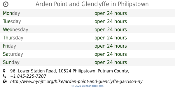
Arden Point and Glenclyffe
96 Lower Station Road, Garrison
Park
read more
3.29 km
Mayor's Park
105 Fair Street, Cold Spring
Park
read more
3.615 km
Хауз Филд
West Point
Park
read more
4.018 km
Буффало Солджер Филд
2110 New South Post Road, Highland Falls
Park
read more
4.018 km
Buffalo Soldier Field
2110 New South Post Road, Highland Falls
Park
read more
📑
all categories
Accounting
Administrative area level 1
Administrative area level 2
Airport
Amusement park
Aquarium
Art gallery
Atm
Bakery
Bank
Bar
Beauty salon
Bicycle store
Book store
Bowling alley
Bus station
Cafe
Campground
Car dealer
Car rental
Car repair
Car wash
Casino
Cemetery
Church
City hall
Clothing store
Colloquial area
Convenience store
Courthouse
Dentist
Department store
Doctor
Electrician
Electronics store
Embassy
Establishment
Finance
Fire station
Florist
Food
Funeral home
Furniture store
Gas station
General contractor
Grocery or supermarket
Gym
Hair care
Hardware store
Health
Hindu Temple
Home goods store
Hospital
Insurance agency
Intersection
Jewelry store
Laundry
Lawyer
Library
Light rail station
Liquor store
Local government office
Locality
Locksmith
Lodging
Meal delivery
Meal takeaway
Mosque
Movie rental
Movie theater
Moving company
Museum
Natural feature
Neighborhood
Night club
Painter
Park
Parking
Pet store
Pharmacy
Physiotherapist
Place of worship
Plumber
Point of interest
Police
Political
Post office
Premise
Real estate agency
Restaurant
Roofing contractor
Route
Rv park, camping
School
Shoe store
Shopping mall
Spa
Stadium
Storage
Store
Subpremise
Subway station
Supermarket
Synagogue
Taxi stand
Train station
Transit station
Travel agency
University
Veterinary care
Zoo
administrative area level 3
sublocality level 1
↑