Meal takeaway nearby Dunkin'
United States
Meal takeaway nearby Dunkin'
Dunkin'
280, Sunrise Highway, 11757, Lindenhurst, Suffolk County, US United States
contacts phone
:
+1 631-206-6113
website:
locations.dunkindonuts.com
Latitude:
40.7077688
, Longitude:
-73.3710715
larger map & directions
read more
nearest Meal takeaway
735 m
Angelina's wieners
610 New York 109, Lindenhurst
Meal takeaway
read more
941 m
Taco Bell
85 E. Sunrise Hwy, Lindenhurst
Meal takeaway
read more
981 m
Chung Hing Chinese Food
385 Sunrise Highway, West Babylon
Meal takeaway
read more
1.039 km
Subway
66 East Sunrise Highway, Lindenhurst
Meal takeaway
Restaurant
Food
Point of interest
Establishment
read more
1.147 km
Dunkin'
41 Sunrise Highway, Lindenhurst
Cafe
Meal takeaway
Bakery
Store
Restaurant
Food
Point of interest
Establishment
read more
1.21 km
Little Caesars Pizza
675 New York 109, West Babylon
Meal takeaway
read more
1.23 km
Foods of Italia
640 North Wellwood Avenue, Lindenhurst
Meal takeaway
read more
1.993 km
Kurt's Deli
278 North Wellwood Avenue, Lindenhurst
Meal takeaway
read more
2.083 km
MB Pizzeria & Restaurant
1030 Little East Neck Road, West Babylon
Meal delivery
Cafe
Meal takeaway
Bar
Store
Restaurant
Food
Point of interest
Establishment
read more
2.394 km
Dunkin'
393 Little East Neck Road #397, West Babylon
Meal takeaway
Bakery
Restaurant
Cafe
Food
Point of interest
Store
Establishment
read more
2.848 km
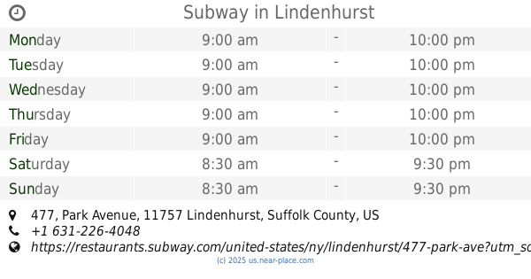
Subway
477 Park Avenue Suite 19, Lindenhurst
Meal takeaway
Restaurant
Food
Point of interest
Establishment
read more
3.011 km
Dunkin'
320 East Montauk Highway, Lindenhurst
Bakery
Cafe
Meal takeaway
Restaurant
Food
Point of interest
Store
Establishment
read more
3.069 km
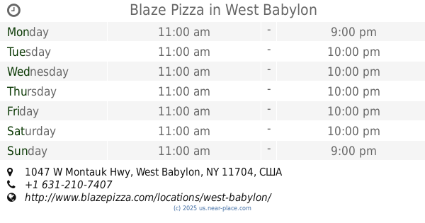
Blaze Pizza
1047 W Montauk Hwy, West Babylon
Meal takeaway
read more
3.117 km
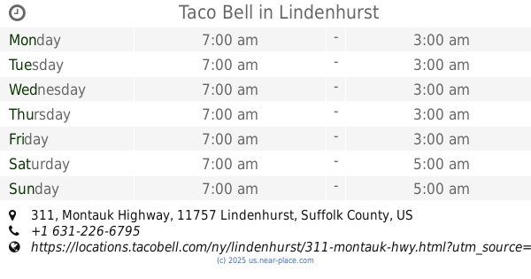
Taco Bell
311 Montauk Highway, Lindenhurst
Meal takeaway
read more
3.339 km
Food & Fun
1228 Wellwood Avenue, West Babylon
Meal takeaway
read more
📑
all categories
Accounting
Administrative area level 1
Administrative area level 2
Airport
Amusement park
Aquarium
Art gallery
Atm
Bakery
Bank
Bar
Beauty salon
Bicycle store
Book store
Bowling alley
Bus station
Cafe
Campground
Car dealer
Car rental
Car repair
Car wash
Casino
Cemetery
Church
City hall
Clothing store
Colloquial area
Convenience store
Courthouse
Dentist
Department store
Doctor
Electrician
Electronics store
Embassy
Establishment
Finance
Fire station
Florist
Food
Funeral home
Furniture store
Gas station
General contractor
Grocery or supermarket
Gym
Hair care
Hardware store
Health
Hindu Temple
Home goods store
Hospital
Insurance agency
Intersection
Jewelry store
Laundry
Lawyer
Library
Light rail station
Liquor store
Local government office
Locality
Locksmith
Lodging
Meal delivery
Meal takeaway
Mosque
Movie rental
Movie theater
Moving company
Museum
Natural feature
Neighborhood
Night club
Painter
Park
Parking
Pet store
Pharmacy
Physiotherapist
Place of worship
Plumber
Point of interest
Police
Political
Post office
Premise
Real estate agency
Restaurant
Roofing contractor
Route
Rv park, camping
School
Shoe store
Shopping mall
Spa
Stadium
Storage
Store
Subpremise
Subway station
Supermarket
Synagogue
Taxi stand
Train station
Transit station
Travel agency
University
Veterinary care
Zoo
administrative area level 3
sublocality level 1
↑