Local government office nearby Taconic Developmental Disablts
United States
Local government office nearby Taconic Developmental Disablts
Taconic Developmental Disablts
43, Overlook Rd, 12564, Pawling, Dutchess County, US Соединенные Штаты Америки
contacts phone
:
+1 845-855-3598
Latitude:
41.555024
, Longitude:
-73.617024
larger map & directions
read more
nearest Local government office
1.391 km
Village Garage
9 Henry Street, Pawling
Local government office
read more
1.595 km
Pawling Building & Zoning Phon
9 Memorial Avenue, Pawling
Local government office
read more
1.595 km
Pawling Village Clerk
9 Memorial Avenue, Pawling
Local government office
read more
1.597 km
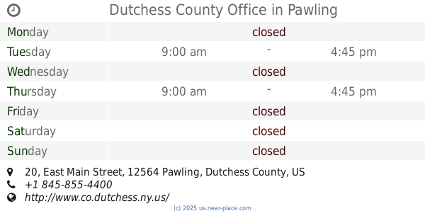
Dutchess County Office
20 East Main Street, Pawling
Local government office
read more
2.114 km
Pawling Zone Administrator
160 Charles Colman Boulevard, Pawling
Local government office
read more
2.114 km
Pawling Town Clerk
160 Charles Colman Boulevard, Pawling
Local government office
read more
2.114 km
Pawling Planning Board
160 Charles Colman Boulevard, Pawling
Local government office
read more
2.114 km
Pawling Town Supervisor
160 Charles Colman Boulevard, Pawling
Local government office
read more
2.862 km
Pawling Sewer Plant
37 Corbin Road, Pawling
Local government office
read more
3.637 km
Pawling Transfer Station
River Road, Pawling
Local government office
read more
4.689 km
Patterson Planning & Zoning
1142 New York 311, Patterson
Local government office
read more
4.69 km
Patterson Supervisor
Patterson
Local government office
read more
4.692 km
The Patterson Town Clerk
1142 New York 311, Patterson
Local government office
read more
10.39 km
Remsen Town Justice Department
Court Ln, Remsen
Local government office
read more
11.893 km
New Fairfield Canine Control
Connecticut 37, New Fairfield
Local government office
read more
📑
all categories
Accounting
Administrative area level 1
Administrative area level 2
Airport
Amusement park
Aquarium
Art gallery
Atm
Bakery
Bank
Bar
Beauty salon
Bicycle store
Book store
Bowling alley
Bus station
Cafe
Campground
Car dealer
Car rental
Car repair
Car wash
Casino
Cemetery
Church
City hall
Clothing store
Colloquial area
Convenience store
Courthouse
Dentist
Department store
Doctor
Electrician
Electronics store
Embassy
Establishment
Finance
Fire station
Florist
Food
Funeral home
Furniture store
Gas station
General contractor
Grocery or supermarket
Gym
Hair care
Hardware store
Health
Hindu Temple
Home goods store
Hospital
Insurance agency
Intersection
Jewelry store
Laundry
Lawyer
Library
Light rail station
Liquor store
Local government office
Locality
Locksmith
Lodging
Meal delivery
Meal takeaway
Mosque
Movie rental
Movie theater
Moving company
Museum
Natural feature
Neighborhood
Night club
Painter
Park
Parking
Pet store
Pharmacy
Physiotherapist
Place of worship
Plumber
Point of interest
Police
Political
Post office
Premise
Real estate agency
Restaurant
Roofing contractor
Route
Rv park, camping
School
Shoe store
Shopping mall
Spa
Stadium
Storage
Store
Subpremise
Subway station
Supermarket
Synagogue
Taxi stand
Train station
Transit station
Travel agency
University
Veterinary care
Zoo
administrative area level 3
sublocality level 1
↑