Local government office nearby Olmsted Center
United States
Local government office nearby Olmsted Center
Olmsted Center
117-2, Roosevelt Avenue, 11368, Queens County, New York, US Соединенные Штаты Америки
contacts phone
:
+1 718-760-6795
website:
www.nycgovparks.org
Latitude:
40.751329
, Longitude:
-73.849454
larger map & directions
read more
nearest Local government office
424 m
Queens Parks Opportunity Program (POP) Center
Meridian Road, Corona
Local government office
read more
486 m
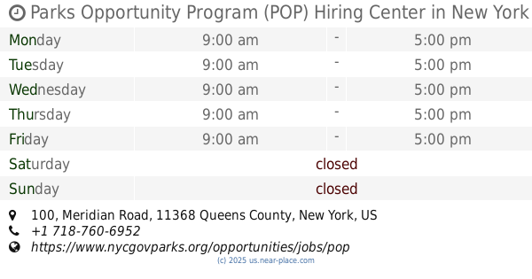
Parks Opportunity Program (POP) Hiring Center
100 Meridian Road, Corona
Local government office
read more
509 m
Passerelle Building
Flushing Meadows Corona Park, Corona
Local government office
read more
521 m
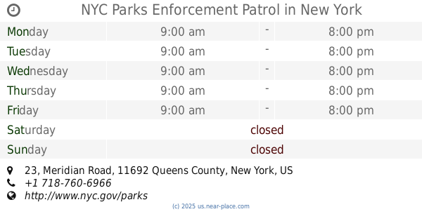
NYC Parks Enforcement Patrol
23 Meridian Road, Queens
Local government office
read more
1.044 km
Queens Community Board 4
4611 104th Street, Corona
Local government office
read more
1.502 km
Nyahma
61-20 Grand Central Parkway, Forest Hills
Local government office
read more
1.504 km
New York City Department of Education
9850 50th Ave, Corona
Local government office
read more
1.646 km
Empire State Development Office
13331 39th Avenue, Flushing
Local government office
read more
1.708 km
Nyc Housing Authority
10803 62nd Drive, Flushing
Local government office
read more
1.859 km
Assembly Member Jeffrion Aubry
9809 Northern Boulevard, Flushing
Local government office
read more
1.906 km
Queens Inspections Department
9605 Horace Harding Expressway, Flushing
Local government office
read more
1.958 km
Assembly Member Grace Meng
13620 38th Avenue # 10A, Flushing
Local government office
read more
2.172 km
Health Management Unit
59-17 Junction Boulevard #1, Queens
Local government office
read more
2.222 km
NYC Department of Environmental Protection
96-05 Horace Harding Expressway, Corona
Local government office
read more
2.231 km
New York City Water Board
59-17 Junction Boulevard, Flushing
Local government office
read more
📑
all categories
Accounting
Administrative area level 1
Administrative area level 2
Airport
Amusement park
Aquarium
Art gallery
Atm
Bakery
Bank
Bar
Beauty salon
Bicycle store
Book store
Bowling alley
Bus station
Cafe
Campground
Car dealer
Car rental
Car repair
Car wash
Casino
Cemetery
Church
City hall
Clothing store
Colloquial area
Convenience store
Courthouse
Dentist
Department store
Doctor
Electrician
Electronics store
Embassy
Establishment
Finance
Fire station
Florist
Food
Funeral home
Furniture store
Gas station
General contractor
Grocery or supermarket
Gym
Hair care
Hardware store
Health
Hindu Temple
Home goods store
Hospital
Insurance agency
Intersection
Jewelry store
Laundry
Lawyer
Library
Light rail station
Liquor store
Local government office
Locality
Locksmith
Lodging
Meal delivery
Meal takeaway
Mosque
Movie rental
Movie theater
Moving company
Museum
Natural feature
Neighborhood
Night club
Painter
Park
Parking
Pet store
Pharmacy
Physiotherapist
Place of worship
Plumber
Point of interest
Police
Political
Post office
Premise
Real estate agency
Restaurant
Roofing contractor
Route
Rv park, camping
School
Shoe store
Shopping mall
Spa
Stadium
Storage
Store
Subpremise
Subway station
Supermarket
Synagogue
Taxi stand
Train station
Transit station
Travel agency
University
Veterinary care
Zoo
administrative area level 3
sublocality level 1
↑