Local government office nearby Department of Family and Protective Services
United States
Local government office nearby Department of Family and Protective Services
Department of Family and Protective Services
1340 Airport Commerce Drive Suite 525, Austin United States
contacts phone
:
+1
Latitude:
30.2245125
, Longitude:
-97.6872271
read more
nearest Local government office
7 m
Boating Safety Division
1340 Airport Commerce Drive #600b, Austin
Local government office
read more
108 m
Texas Department of Rural Affairs - Disaster Recovery
1340 Airport Commerce Drive, Austin
Local government office
read more
2.068 km
FSC
7600 Metropolis Drive, Austin
Local government office
read more
3.648 km
Austin Fire Department - Station 15
829 Airport Boulevard, Austin
Local government office
read more
6.333 km
Travis County Veterans Services
100 East 1st Street, Austin
Local government office
read more
6.34 km
Travis County Health & Human Services
100 North Interstate 35 Frontage Road #2000, Austin
Local government office
read more
6.343 km
Lawrence Group Architects
900 East 6th Street # 105, Austin
Local government office
read more
6.344 km
Coming of Age Austin Metro
100 N I H 35 # 3800, Austin
Local government office
read more
6.518 km
Downtown Austin Community Court
719 East 6th Street, Austin
Local government office
read more
6.619 km
Austin City Prosecutor's Office
700 East 7th Street, Austin
Local government office
read more
6.621 km
Texas Lottery Commission
611 East 6th Street, Austin
Local government office
read more
6.688 km
Austin Fleet Services Center
714 East 8th Street, Austin
Local government office
read more
6.702 km
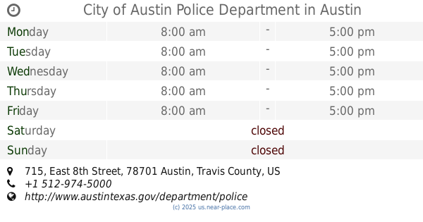
City of Austin Police Department
715 East 8th Street, Austin
Local government office
read more
7.051 km
US Labor Department Wage & Hour Division
300 East 8th Street, Austin
Local government office
read more
7.051 km
Senator Kay Bailey Hutchison
300 East 8th Street #961, Austin
Local government office
read more
📑
all categories
Accounting
Administrative area level 1
Administrative area level 2
Airport
Amusement park
Aquarium
Art gallery
Atm
Bakery
Bank
Bar
Beauty salon
Bicycle store
Book store
Bowling alley
Bus station
Cafe
Campground
Car dealer
Car rental
Car repair
Car wash
Casino
Cemetery
Church
City hall
Clothing store
Colloquial area
Convenience store
Courthouse
Dentist
Department store
Doctor
Electrician
Electronics store
Embassy
Establishment
Finance
Fire station
Florist
Food
Funeral home
Furniture store
Gas station
General contractor
Grocery or supermarket
Gym
Hair care
Hardware store
Health
Hindu Temple
Home goods store
Hospital
Insurance agency
Intersection
Jewelry store
Laundry
Lawyer
Library
Light rail station
Liquor store
Local government office
Locality
Locksmith
Lodging
Meal delivery
Meal takeaway
Mosque
Movie rental
Movie theater
Moving company
Museum
Natural feature
Neighborhood
Night club
Painter
Park
Parking
Pet store
Pharmacy
Physiotherapist
Place of worship
Plumber
Point of interest
Police
Political
Post office
Premise
Real estate agency
Restaurant
Roofing contractor
Route
Rv park, camping
School
Shoe store
Shopping mall
Spa
Stadium
Storage
Store
Subpremise
Subway station
Supermarket
Synagogue
Taxi stand
Train station
Transit station
Travel agency
University
Veterinary care
Zoo
administrative area level 3
sublocality level 1
↑