Local government office nearby County-Suffolk South
United States
Local government office nearby County-Suffolk South
County-Suffolk South
Montauk Highway, 11967, Shirley, Suffolk County, US Соединенные Штаты Америки
contacts phone
:
+1 631-281-9833
Latitude:
40.8009514
, Longitude:
-72.8695556
larger map & directions
read more
nearest Local government office
175 m
Suffolk County Park Police
Shirley
Local government office
read more
1.005 km
Suffolk County Legislature
1120 Montauk Highway, Mastic
Local government office
read more
4.224 km
United States Governments
20 Washington Avenue, Mastic Beach
Local government office
read more
4.252 km
Suffolk County Criminal Justice
110 East Avenue, Yaphank
Local government office
read more
4.372 km
Suffolk County Fire Academy
676 Maple Ave, Yaphank
Local government office
read more
4.545 km
Suffolk County Police-Theft
1491 William Floyd Parkway, Shirley
Local government office
read more
4.619 km
Criminal Intelligence Bureau
30 Yaphank Avenue, Yaphank
Local government office
read more
4.688 km
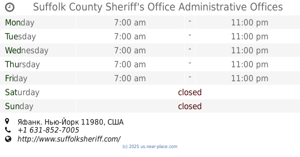
Suffolk County Sheriff's Office Administrative Offices
Yaphank
Local government office
read more
4.888 km
Suffolk County Sanitation Division
335 Yaphank Avenue, Yaphank
Local government office
read more
4.894 km
Suffolk County General Services
335 Yaphank Avenue # 10, Yaphank
Local government office
read more
4.942 km
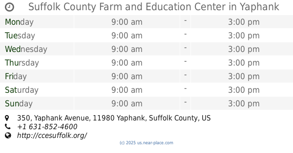
Suffolk County Farm and Education Center
350 Yaphank Avenue, Yaphank
Local government office
read more
5.181 km
Suffolk County Division of Environmental Quality
360 Yaphank Avenue #2b, Yaphank
Local government office
read more
5.208 km
Suffolk County Sheriff's Office
360 Yaphank Avenue, Yaphank
Local government office
read more
5.211 km
Suffolk County Purchasing Division
360 Yaphank Avenue, Yaphank
Local government office
read more
5.238 km
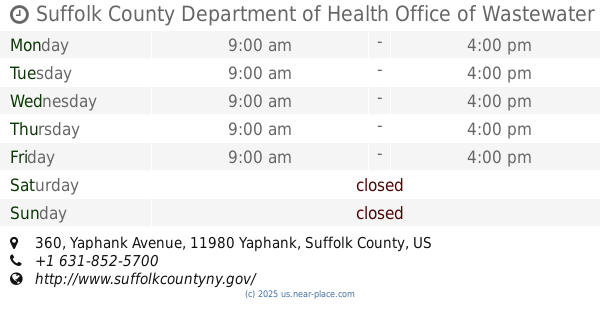
Suffolk County Department of Health Office of Wastewater Management
360 Yaphank Avenue # 2C, Yaphank
Local government office
read more
📑
all categories
Accounting
Administrative area level 1
Administrative area level 2
Airport
Amusement park
Aquarium
Art gallery
Atm
Bakery
Bank
Bar
Beauty salon
Bicycle store
Book store
Bowling alley
Bus station
Cafe
Campground
Car dealer
Car rental
Car repair
Car wash
Casino
Cemetery
Church
City hall
Clothing store
Colloquial area
Convenience store
Courthouse
Dentist
Department store
Doctor
Electrician
Electronics store
Embassy
Establishment
Finance
Fire station
Florist
Food
Funeral home
Furniture store
Gas station
General contractor
Grocery or supermarket
Gym
Hair care
Hardware store
Health
Hindu Temple
Home goods store
Hospital
Insurance agency
Intersection
Jewelry store
Laundry
Lawyer
Library
Light rail station
Liquor store
Local government office
Locality
Locksmith
Lodging
Meal delivery
Meal takeaway
Mosque
Movie rental
Movie theater
Moving company
Museum
Natural feature
Neighborhood
Night club
Painter
Park
Parking
Pet store
Pharmacy
Physiotherapist
Place of worship
Plumber
Point of interest
Police
Political
Post office
Premise
Real estate agency
Restaurant
Roofing contractor
Route
Rv park, camping
School
Shoe store
Shopping mall
Spa
Stadium
Storage
Store
Subpremise
Subway station
Supermarket
Synagogue
Taxi stand
Train station
Transit station
Travel agency
University
Veterinary care
Zoo
administrative area level 3
sublocality level 1
↑