Local government office nearby Bronx Community Board
United States
Local government office nearby Bronx Community Board
Bronx Community Board
1426, Boston Road, 10456, Bronx County, New York, US Соединенные Штаты Америки
contacts phone
:
+1 718-378-8054
website:
www.nyc.gov
Latitude:
40.8331523
, Longitude:
-73.896798
larger map & directions
read more
nearest Local government office
363 m
New York City Housing Authority's Franklin Avenue I (Conventional)
1381 Franklin Avenue, Bronx
Local government office
read more
450 m
Housing Works
1344 Elmo Hope Way, Bronx
Local government office
read more
637 m
Home Assistance Technician Fordham Bedford Housing Corp.
950 Jennings Street, Bronx
Local government office
read more
762 m
Нью-Йорк Сити Хаузинг Оторитис Гувернер Моррис I
1385 Washington Avenue, Bronx
Local government office
read more
764 m
New York City Housing Auth
1385 Washington Avenue, Bronx
Local government office
read more
885 m
New York City Housing Authority's West Farms Square MHOP
1252 West Farms Road, Bronx
Local government office
read more
893 m
New York City Housing Authority's Hoe Avenue-East 173rd Street
1700 Hoe Avenue, Bronx
Local government office
read more
908 m
Statcare Urgent Care Bronx 174th St. NY
932 East 174th Street, Bronx
Local government office
read more
942 m
MBD Community Housing Corporation
1762 Boston Road, Bronx
Local government office
read more
989 m
Housing Authority Management
1705 Bryant Avenue, Bronx
Local government office
read more
1.005 km
NYSDOH Aids Institute
897 Crotona Park North, Bronx
Local government office
read more
1.077 km
New York City Housing Authority's East 165th Street-Bryant Avenue
1084 Bryant Avenue, Bronx
Local government office
read more
1.132 km
NYC Housing Authority Forest
1010 Trinity Avenue, Bronx
Local government office
read more
1.136 km
Mc Kinley Houses
1010 Trinity Avenue, Bronx
Local government office
read more
1.14 km
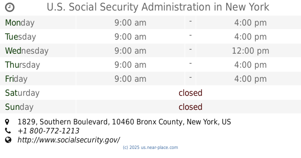
U.S. Social Security Administration
1829 Southern Boulevard, Bronx
Local government office
read more
📑
all categories
Accounting
Administrative area level 1
Administrative area level 2
Airport
Amusement park
Aquarium
Art gallery
Atm
Bakery
Bank
Bar
Beauty salon
Bicycle store
Book store
Bowling alley
Bus station
Cafe
Campground
Car dealer
Car rental
Car repair
Car wash
Casino
Cemetery
Church
City hall
Clothing store
Colloquial area
Convenience store
Courthouse
Dentist
Department store
Doctor
Electrician
Electronics store
Embassy
Establishment
Finance
Fire station
Florist
Food
Funeral home
Furniture store
Gas station
General contractor
Grocery or supermarket
Gym
Hair care
Hardware store
Health
Hindu Temple
Home goods store
Hospital
Insurance agency
Intersection
Jewelry store
Laundry
Lawyer
Library
Light rail station
Liquor store
Local government office
Locality
Locksmith
Lodging
Meal delivery
Meal takeaway
Mosque
Movie rental
Movie theater
Moving company
Museum
Natural feature
Neighborhood
Night club
Painter
Park
Parking
Pet store
Pharmacy
Physiotherapist
Place of worship
Plumber
Point of interest
Police
Political
Post office
Premise
Real estate agency
Restaurant
Roofing contractor
Route
Rv park, camping
School
Shoe store
Shopping mall
Spa
Stadium
Storage
Store
Subpremise
Subway station
Supermarket
Synagogue
Taxi stand
Train station
Transit station
Travel agency
University
Veterinary care
Zoo
administrative area level 3
sublocality level 1
↑