Grocery or supermarket nearby Whole Foods Market
United States
Grocery or supermarket nearby Whole Foods Market
Whole Foods Market
11701, South Dixie Highway, 33156, Pinecrest, Miami-Dade County, US United States
contacts phone
:
+1 305-969-5800
website:
www.wholefoodsmarket.com
Latitude:
25.6623143
, Longitude:
-80.3246683
larger map & directions
read more
nearest Grocery or supermarket
2.119 km
Che Pibe
9600 Southwest 77th Avenue, Miami
Grocery or supermarket
read more
2.365 km
The Fresh Market
8760 Southwest 136th Street, Miami
Grocery or supermarket
read more
2.735 km
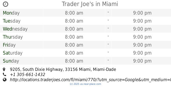
Trader Joe's
9205 South Dixie Highway, Miami
Grocery or supermarket
read more
2.767 km
Publix
9133 Dadeland Boulevard, Kendall
Grocery or supermarket
read more
3.81 km
ALDI
15033 South Dixie Highway S Dixie Hwy, Palmetto Bay
Grocery or supermarket
read more
4.831 km
Green Matcha Products co
5811 Southwest 88th Street, Miami
Grocery or supermarket
read more
6.323 km
Whole Foods Market
6701 Red Road, Coral Gables
Grocery or supermarket
read more
6.323 km
Whole Foods Market
6701 South Red Road, Coral Gables
Grocery or supermarket
read more
15.83 km
Aladino Market
1410 Southwest 6th Street, Miami
Grocery or supermarket
read more
15.924 km
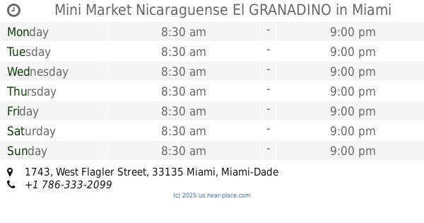
Mini Market Nicaraguense El GRANADINO
1743 West Flagler Street, Miami
Grocery or supermarket
read more
16.073 km
Lazaro Supermarket
1400 Southwest 3rd Street, Miami
Grocery or supermarket
read more
16.723 km
Mas X Menos Market Corporation
9 Northwest 11th Avenue, Miami
Grocery or supermarket
read more
17.027 km
Manolito's
21 Southwest 8th Avenue, Miami
Grocery or supermarket
read more
17.852 km
Brickell Foods & Wine LLC
70 Southeast 5th Street, Miami
Grocery or supermarket
read more
18.479 km
Crew Stop
252 Northeast 1st Street, Miami
Grocery or supermarket
read more
📑
all categories
Accounting
Administrative area level 1
Administrative area level 2
Airport
Amusement park
Aquarium
Art gallery
Atm
Bakery
Bank
Bar
Beauty salon
Bicycle store
Book store
Bowling alley
Bus station
Cafe
Campground
Car dealer
Car rental
Car repair
Car wash
Casino
Cemetery
Church
City hall
Clothing store
Colloquial area
Convenience store
Courthouse
Dentist
Department store
Doctor
Electrician
Electronics store
Embassy
Establishment
Finance
Fire station
Florist
Food
Funeral home
Furniture store
Gas station
General contractor
Grocery or supermarket
Gym
Hair care
Hardware store
Health
Hindu Temple
Home goods store
Hospital
Insurance agency
Intersection
Jewelry store
Laundry
Lawyer
Library
Light rail station
Liquor store
Local government office
Locality
Locksmith
Lodging
Meal delivery
Meal takeaway
Mosque
Movie rental
Movie theater
Moving company
Museum
Natural feature
Neighborhood
Night club
Painter
Park
Parking
Pet store
Pharmacy
Physiotherapist
Place of worship
Plumber
Point of interest
Police
Political
Post office
Premise
Real estate agency
Restaurant
Roofing contractor
Route
Rv park, camping
School
Shoe store
Shopping mall
Spa
Stadium
Storage
Store
Subpremise
Subway station
Supermarket
Synagogue
Taxi stand
Train station
Transit station
Travel agency
University
Veterinary care
Zoo
administrative area level 3
sublocality level 1
↑