Grocery or supermarket nearby Kroger
United States
Grocery or supermarket nearby Kroger
Kroger
12600, North Beach Street, 76244, Fort Worth, Tarrant County, US Соединенные Штаты Америки
contacts phone
:
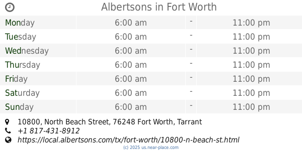
+1 817-562-3900
website:
www.kroger.com
Latitude:
32.9563188
, Longitude:
-97.2799585
larger map & directions
read more
nearest Grocery or supermarket
2.221 km
Pic Up Mart- C Store
11477 Woodland Springs Drive, Fort Worth
Grocery or supermarket
read more
3.07 km
Albertsons
10800 North Beach Street, Fort Worth
Grocery or supermarket
read more
4.194 km
Bear Creek deli Food Mart
101 Bear Creek Parkway, Keller
Grocery or supermarket
read more
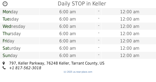
4.729 km
Daily STOP
797 Keller Parkway, Keller
Grocery or supermarket
read more
5.156 km
Gruma Mission Foods
800 Henrietta Creek Road, Roanoke
Grocery or supermarket
read more
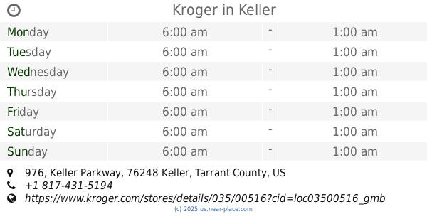
5.347 km
Kroger
976 Keller Parkway, Keller
Grocery or supermarket
read more
5.538 km
Tom Thumb
1000 Keller Parkway, Keller
Grocery or supermarket
read more
5.633 km
United Supermarkets
200 Freedom Drive, Roanoke
Grocery or supermarket
read more
5.665 km
Kroger Marketplace
3300 Texas Sage Trail, Fort Worth
Grocery or supermarket
read more
5.847 km
Grapevine Olive Oil Co.-Alliance Town Center
2924 Texas Sage Trail, Fort Worth
Grocery or supermarket
read more
6.43 km
Hidden Oaks Country Market
1099 School House Road c, Haslet
Grocery or supermarket
read more
8.909 km
Sprouts Farmers Market
220 Randol Mill Avenue, Southlake
Grocery or supermarket
read more
14.146 km
Trader Joe's
1492 East Southlake Boulevard, Southlake
Grocery or supermarket
read more
14.262 km
Schreiber Foods
1516 Main Street, Southlake
Grocery or supermarket
read more
17.478 km
24/7 Food Mart
560 West Pipeline Road, Hurst
Grocery or supermarket
read more
📑
all categories
Accounting
Administrative area level 1
Administrative area level 2
Airport
Amusement park
Aquarium
Art gallery
Atm
Bakery
Bank
Bar
Beauty salon
Bicycle store
Book store
Bowling alley
Bus station
Cafe
Campground
Car dealer
Car rental
Car repair
Car wash
Casino
Cemetery
Church
City hall
Clothing store
Colloquial area
Convenience store
Courthouse
Dentist
Department store
Doctor
Electrician
Electronics store
Embassy
Establishment
Finance
Fire station
Florist
Food
Funeral home
Furniture store
Gas station
General contractor
Grocery or supermarket
Gym
Hair care
Hardware store
Health
Hindu Temple
Home goods store
Hospital
Insurance agency
Intersection
Jewelry store
Laundry
Lawyer
Library
Light rail station
Liquor store
Local government office
Locality
Locksmith
Lodging
Meal delivery
Meal takeaway
Mosque
Movie rental
Movie theater
Moving company
Museum
Natural feature
Neighborhood
Night club
Painter
Park
Parking
Pet store
Pharmacy
Physiotherapist
Place of worship
Plumber
Point of interest
Police
Political
Post office
Premise
Real estate agency
Restaurant
Roofing contractor
Route
Rv park, camping
School
Shoe store
Shopping mall
Spa
Stadium
Storage
Store
Subpremise
Subway station
Supermarket
Synagogue
Taxi stand
Train station
Transit station
Travel agency
University
Veterinary care
Zoo
administrative area level 3
sublocality level 1
↑