Food nearby Juice It Up!
United States
Food nearby Juice It Up!
Juice It Up!
4850, Little Road, 76017, Arlington, Tarrant County, US Соединенные Штаты Америки
contacts phone
:
+1 682-808-0806
website:
www.juiceitup.com
Latitude:
32.670848
, Longitude:
-97.2041707
larger map & directions
read more
nearest Food
687 m
Gronbach Food Systems LLC
5840 Interstate 20 Frontage Road # 200, Arlington
Food
read more
930 m
M D Foods Inc
4401 Little Road, Arlington
Food
read more
987 m
Discount Party Rentals
5744 Southwest Green Oaks Boulevard, Arlington
Food
read more
1.046 km
Black Rock Coffee Bar
5723 West Interstate 20, Arlington
Cafe
Store
Food
Point of interest
Establishment
read more
1.085 km
Dunkin'
5801 Office Park Drive, Arlington
Cafe
Bakery
Meal takeaway
Restaurant
Store
Food
Point of interest
Establishment
read more
1.575 km
Cafe Acapulco
4478, 4001 West Green Oaks Boulevard #121, Arlington
Cafe
Restaurant
Point of interest
Food
Establishment
read more
1.6 km
Bounce House Rental
4001 West Green Oaks Boulevard, Arlington
Food
read more
1.674 km
Fred Arrants Darwin Jr
4515 Grey Dawn Drive, Arlington
Food
read more
2.966 km
Unique Catering & Party Planners
324 West Kennedale Parkway, Kennedale
Food
read more
4.962 km
True Seed
5109 Wilbarger Street, Fort Worth
Food
read more
5.018 km
Grounds and Gold Co.
4130 South Bowen Road, Arlington
Cafe
Food
Point of interest
Store
Establishment
read more
5.463 km
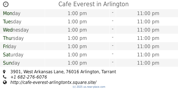
Cafe Everest
3901 West Arkansas Lane #107A, Arlington
Restaurant
Cafe
Store
Point of interest
Food
Establishment
read more
5.991 km
Baklava Bakery & Cafe
3115 West Arkansas Lane, Arlington
Food
read more
6.291 km
Chelsea's Tea Room & Boutique
3291 West Pioneer Parkway, Pantego
Cafe
Food
Point of interest
Store
Establishment
read more
6.325 km
Compadres Cafe
2705 West Arkansas Lane, Arlington
Cafe
Food
Point of interest
Establishment
read more
📑
all categories
Accounting
Administrative area level 1
Administrative area level 2
Airport
Amusement park
Aquarium
Art gallery
Atm
Bakery
Bank
Bar
Beauty salon
Bicycle store
Book store
Bowling alley
Bus station
Cafe
Campground
Car dealer
Car rental
Car repair
Car wash
Casino
Cemetery
Church
City hall
Clothing store
Colloquial area
Convenience store
Courthouse
Dentist
Department store
Doctor
Electrician
Electronics store
Embassy
Establishment
Finance
Fire station
Florist
Food
Funeral home
Furniture store
Gas station
General contractor
Grocery or supermarket
Gym
Hair care
Hardware store
Health
Hindu Temple
Home goods store
Hospital
Insurance agency
Intersection
Jewelry store
Laundry
Lawyer
Library
Light rail station
Liquor store
Local government office
Locality
Locksmith
Lodging
Meal delivery
Meal takeaway
Mosque
Movie rental
Movie theater
Moving company
Museum
Natural feature
Neighborhood
Night club
Painter
Park
Parking
Pet store
Pharmacy
Physiotherapist
Place of worship
Plumber
Point of interest
Police
Political
Post office
Premise
Real estate agency
Restaurant
Roofing contractor
Route
Rv park, camping
School
Shoe store
Shopping mall
Spa
Stadium
Storage
Store
Subpremise
Subway station
Supermarket
Synagogue
Taxi stand
Train station
Transit station
Travel agency
University
Veterinary care
Zoo
administrative area level 3
sublocality level 1
↑