Convenience store nearby Walgreens
United States
Convenience store nearby Walgreens
Walgreens
833, Roosevelt Avenue, 07008, Carteret, Middlesex County, US Соединенные Штаты Америки
contacts phone
:
+1 732-969-1441
website:
www.walgreens.com
Latitude:
40.5901156
, Longitude:
-74.2291448
larger map & directions
read more
nearest Convenience store
220 m
CVS
837 Roosevelt Avenue, Carteret
Convenience store
read more
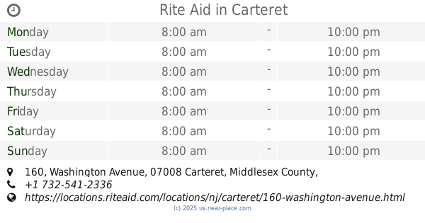
1.218 km
Rite Aid
160 Washington Avenue, Carteret
Convenience store
read more
1.223 km
7-Eleven
1299 Roosevelt Avenue, Carteret
Convenience store
read more
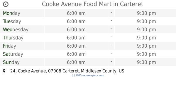
1.623 km
Cooke Avenue Food Mart
24 Cooke Avenue, Carteret
Convenience store
read more
2.176 km
Ситго
Tremley Point Road, Linden
Convenience store
read more
2.176 km
CITGO Petroleum Corporation
Tremley Point Road, Linden
Convenience store
read more
2.62 km
Krauszer's Port Food
643 Port Reading Avenue, Port Reading
Convenience store
read more
2.949 km
Big E's Deli
172 West Service Road, Staten Island
Convenience store
read more
3.298 km
QuickChek
1171 Woodbridge Road, Rahway
Convenience store
read more
3.501 km
Krauser's Food Stores
501 East Grand Avenue, Rahway
Convenience store
read more
3.713 km
Sunny Mart Food Store & Deli
301 Port Reading Avenue # 3, Port Reading
Convenience store
read more
4.411 km
7-Eleven
1099 Route 1, Avenel
Convenience store
read more
4.657 km
Rodgers Convenience Store
1608 Irving Street, Rahway
Convenience store
read more
4.74 km
6-Eleven
297 West Grand Avenue, Rahway
Convenience store
read more
4.969 km
Pitstop Colonia
160 West Lake Avenue, Rahway
Convenience store
read more
📑
all categories
Accounting
Administrative area level 1
Administrative area level 2
Airport
Amusement park
Aquarium
Art gallery
Atm
Bakery
Bank
Bar
Beauty salon
Bicycle store
Book store
Bowling alley
Bus station
Cafe
Campground
Car dealer
Car rental
Car repair
Car wash
Casino
Cemetery
Church
City hall
Clothing store
Colloquial area
Convenience store
Courthouse
Dentist
Department store
Doctor
Electrician
Electronics store
Embassy
Establishment
Finance
Fire station
Florist
Food
Funeral home
Furniture store
Gas station
General contractor
Grocery or supermarket
Gym
Hair care
Hardware store
Health
Hindu Temple
Home goods store
Hospital
Insurance agency
Intersection
Jewelry store
Laundry
Lawyer
Library
Light rail station
Liquor store
Local government office
Locality
Locksmith
Lodging
Meal delivery
Meal takeaway
Mosque
Movie rental
Movie theater
Moving company
Museum
Natural feature
Neighborhood
Night club
Painter
Park
Parking
Pet store
Pharmacy
Physiotherapist
Place of worship
Plumber
Point of interest
Police
Political
Post office
Premise
Real estate agency
Restaurant
Roofing contractor
Route
Rv park, camping
School
Shoe store
Shopping mall
Spa
Stadium
Storage
Store
Subpremise
Subway station
Supermarket
Synagogue
Taxi stand
Train station
Transit station
Travel agency
University
Veterinary care
Zoo
administrative area level 3
sublocality level 1
↑