Convenience store nearby Rite Aid
United States
Convenience store nearby Rite Aid
Rite Aid
5102, 13th Avenue, 11219, Kings County, New York, US Соединенные Штаты Америки
contacts phone
:
+1 718-435-5684
website:
locations.riteaid.com
Latitude:
40.6338602
, Longitude:
-73.9936444
larger map & directions
read more
nearest Convenience store
281 m
Meyan Convenience
1207 49th Street, Brooklyn
Convenience store
read more
699 m
New Fort Hamilton Candy-Grocery
4501 Fort Hamilton Parkway, Brooklyn
Convenience store
read more
701 m
Prestige Store Fixtures
4209 13th Avenue, Brooklyn
Convenience store
read more
705 m
Not Just Bagel Store & Grocery
5914 14th Avenue, Brooklyn
Convenience store
read more
769 m
Walgreens
4714 16th Avenue, Brooklyn
Convenience store
read more
803 m
Duane Reade
4721 16th Avenue, Brooklyn
Convenience store
read more
823 m
Sley Ice Cream
4217 Fort Hamilton Parkway, Brooklyn
Convenience store
read more
1.032 km
The Canteen on 13
3808 13th Avenue, Brooklyn
Convenience store
read more
1.252 km
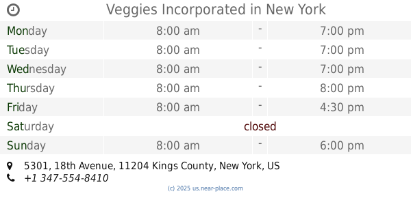
Veggies Incorporated
5301 18th Avenue, Brooklyn
Convenience store
read more
1.289 km
Peng Cheng Trading Inc
5821 8th Avenue, Brooklyn
Convenience store
read more
1.641 km
CVS
411 Ditmas Avenue, Brooklyn
Convenience store
read more
1.755 km
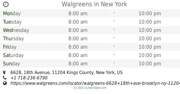
Walgreens
6628 18th Avenue, Brooklyn
Convenience store
read more
1.904 km
Duane Reade
5008 5th Avenue, Brooklyn
Convenience store
read more
1.953 km
Bolla market
3132 Fort Hamilton Parkway, Brooklyn
Convenience store
read more
2.004 km
Pick Quick Foods
4320 5th Avenue, Brooklyn
Convenience store
read more
📑
all categories
Accounting
Administrative area level 1
Administrative area level 2
Airport
Amusement park
Aquarium
Art gallery
Atm
Bakery
Bank
Bar
Beauty salon
Bicycle store
Book store
Bowling alley
Bus station
Cafe
Campground
Car dealer
Car rental
Car repair
Car wash
Casino
Cemetery
Church
City hall
Clothing store
Colloquial area
Convenience store
Courthouse
Dentist
Department store
Doctor
Electrician
Electronics store
Embassy
Establishment
Finance
Fire station
Florist
Food
Funeral home
Furniture store
Gas station
General contractor
Grocery or supermarket
Gym
Hair care
Hardware store
Health
Hindu Temple
Home goods store
Hospital
Insurance agency
Intersection
Jewelry store
Laundry
Lawyer
Library
Light rail station
Liquor store
Local government office
Locality
Locksmith
Lodging
Meal delivery
Meal takeaway
Mosque
Movie rental
Movie theater
Moving company
Museum
Natural feature
Neighborhood
Night club
Painter
Park
Parking
Pet store
Pharmacy
Physiotherapist
Place of worship
Plumber
Point of interest
Police
Political
Post office
Premise
Real estate agency
Restaurant
Roofing contractor
Route
Rv park, camping
School
Shoe store
Shopping mall
Spa
Stadium
Storage
Store
Subpremise
Subway station
Supermarket
Synagogue
Taxi stand
Train station
Transit station
Travel agency
University
Veterinary care
Zoo
administrative area level 3
sublocality level 1
↑