Convenience store nearby Rite Aid
United States
Convenience store nearby Rite Aid
Rite Aid
289 Greenwood Avenue, Bethel Israel
contacts phone
:
+1
Latitude:
41.3753877
, Longitude:
-73.4234902
read more
nearest Convenience store
67 m
H & R Convenience LLC
295 Greenwood Avenue, Bethel
Convenience store
read more
761 m
CVS
7 Durant Avenue, Bethel
Convenience store
read more
1.817 km
La Tienda Grocery & Deli
49 South Street, Danbury
Convenience store
read more
2.059 km
CVS
146 South Street, Danbury
Convenience store
read more
2.539 km
FOOD BAG #546
63 Main Street, Danbury
Convenience store
read more
2.643 km
Walgreens
75 Main Street # 83, Danbury
Convenience store
read more
2.788 km
CVS
303 White Street, Danbury
Convenience store
read more
2.812 km
J & R Shelter Rock Road LLC
2 Old Shelter Rock Road, Danbury
Convenience store
read more
2.89 km
Son Atlantic Market
135 Main Street # 1, Danbury
Convenience store
read more
2.974 km
Quick Stop
241 White Street, Danbury
Convenience store
read more
3.377 km
Lula's Market LLC
78 White Street, Danbury
Convenience store
read more
3.416 km
Danbury Food & Variety Inc
121 White Street, Danbury
Convenience store
read more
4.157 km
Rite Aid
30 Germantown Road, Danbury
Convenience store
read more
4.466 km
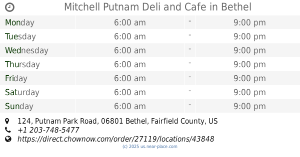
Mitchell Putnam Deli and Cafe
124 Putnam Park Road, Bethel
Convenience store
Cafe
Store
Food
Point of interest
Establishment
read more
4.925 km
Rite Aid
1 Padanaram Road Suite B, Danbury
Convenience store
read more
📑
all categories
Accounting
Administrative area level 1
Administrative area level 2
Airport
Amusement park
Aquarium
Art gallery
Atm
Bakery
Bank
Bar
Beauty salon
Bicycle store
Book store
Bowling alley
Bus station
Cafe
Campground
Car dealer
Car rental
Car repair
Car wash
Casino
Cemetery
Church
City hall
Clothing store
Colloquial area
Convenience store
Courthouse
Dentist
Department store
Doctor
Electrician
Electronics store
Embassy
Establishment
Finance
Fire station
Florist
Food
Funeral home
Furniture store
Gas station
General contractor
Grocery or supermarket
Gym
Hair care
Hardware store
Health
Hindu Temple
Home goods store
Hospital
Insurance agency
Intersection
Jewelry store
Laundry
Lawyer
Library
Light rail station
Liquor store
Local government office
Locality
Locksmith
Lodging
Meal delivery
Meal takeaway
Mosque
Movie rental
Movie theater
Moving company
Museum
Natural feature
Neighborhood
Night club
Painter
Park
Parking
Pet store
Pharmacy
Physiotherapist
Place of worship
Plumber
Point of interest
Police
Political
Post office
Premise
Real estate agency
Restaurant
Roofing contractor
Route
Rv park, camping
School
Shoe store
Shopping mall
Spa
Stadium
Storage
Store
Subpremise
Subway station
Supermarket
Synagogue
Taxi stand
Train station
Transit station
Travel agency
University
Veterinary care
Zoo
administrative area level 3
sublocality level 1
↑