Convenience store nearby CVS
United States
Convenience store nearby CVS
CVS
3327 Rosecrans Street, San Diego Forenede Stater
contacts phone
:
+1
Latitude:
32.7471102
, Longitude:
-117.2060102
read more
nearest Convenience store
291 m
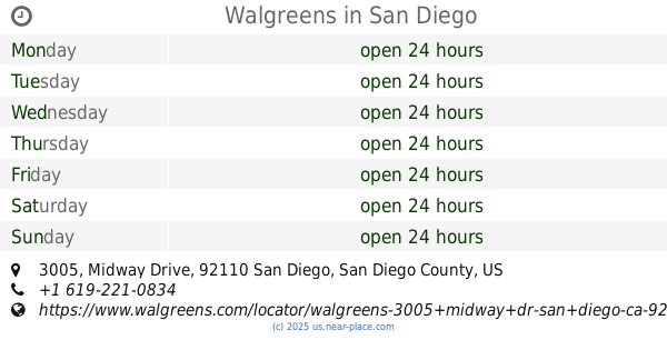
Walgreens
3005 Midway Drive, San Diego
Convenience store
read more
455 m
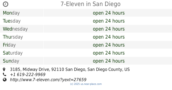
7-Eleven
3185 Midway Drive, San Diego
Convenience store
read more
609 m
7-Eleven
3146 Sports Arena Boulevard, San Diego
Convenience store
read more
632 m
ampm
2940 Lytton Street, San Diego
Convenience store
read more
1.036 km
ampm
3580 Sports Arena Boulevard, San Diego
Convenience store
read more
1.587 km
Old Town Market
3225 North Harbor Drive, San Diego
Convenience store
read more
1.761 km
Neighbor Saver Food Store
3960 West Point Loma Boulevard # H, San Diego
Convenience store
read more
1.766 km
CVS
3950 West Point Loma Boulevard, San Diego
Convenience store
read more
1.781 km
7-Eleven
4101 West Point Loma Boulevard, San Diego
Convenience store
read more
1.796 km
Ciao Gourmet Market
3325 North Harbor Drive, San Diego
Convenience store
read more
2.004 km
7-Eleven
2920 Adrian Street, San Diego
Convenience store
read more
2.031 km
Shell Food Mart
4201 W Point Loma Blvd, San Diego
Convenience store
read more
2.558 km
7-Eleven
1826 Rosecrans Street, San Diego
Convenience store
read more
2.709 km
NEX Mini Mart
2912 Nimitz Boulevard #472, San Diego
Convenience store
read more
3.647 km
Stars & Stripes Mart
2907 Shelter Island Drive # 111, San Diego
Convenience store
read more
📑
all categories
Accounting
Administrative area level 1
Administrative area level 2
Airport
Amusement park
Aquarium
Art gallery
Atm
Bakery
Bank
Bar
Beauty salon
Bicycle store
Book store
Bowling alley
Bus station
Cafe
Campground
Car dealer
Car rental
Car repair
Car wash
Casino
Cemetery
Church
City hall
Clothing store
Colloquial area
Convenience store
Courthouse
Dentist
Department store
Doctor
Electrician
Electronics store
Embassy
Establishment
Finance
Fire station
Florist
Food
Funeral home
Furniture store
Gas station
General contractor
Grocery or supermarket
Gym
Hair care
Hardware store
Health
Hindu Temple
Home goods store
Hospital
Insurance agency
Intersection
Jewelry store
Laundry
Lawyer
Library
Light rail station
Liquor store
Local government office
Locality
Locksmith
Lodging
Meal delivery
Meal takeaway
Mosque
Movie rental
Movie theater
Moving company
Museum
Natural feature
Neighborhood
Night club
Painter
Park
Parking
Pet store
Pharmacy
Physiotherapist
Place of worship
Plumber
Point of interest
Police
Political
Post office
Premise
Real estate agency
Restaurant
Roofing contractor
Route
Rv park, camping
School
Shoe store
Shopping mall
Spa
Stadium
Storage
Store
Subpremise
Subway station
Supermarket
Synagogue
Taxi stand
Train station
Transit station
Travel agency
University
Veterinary care
Zoo
administrative area level 3
sublocality level 1
↑