Convenience store nearby COHN CORNER STORE
United States
Convenience store nearby COHN CORNER STORE
COHN CORNER STORE
2215 Cohn Street, Houston United States
contacts phone
:
+1
Latitude:
29.779572
, Longitude:
-95.4222458
read more
nearest Convenience store
Sunshine Food Mart
2215 Cohn Street, Houston
Convenience store
read more
479 m
STAR STOP 62
5401 KATY FRWY,HOUSTON TX 77040, Houston
Convenience store
read more
627 m
Larkin Mart
5243 Larkin Street, Houston
Convenience store
read more
658 m
Danny's MKT
6633 Washington Avenue, Houston
Convenience store
read more
890 m
Super K Food Store
6111 Washington Avenue, Houston
Convenience store
read more
1.161 km
CVS
5401 Washington Avenue, Houston
Convenience store
read more
1.294 km
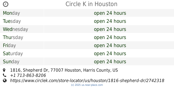
Circle K
1816 Shepherd Dr, Houston
Convenience store
read more
1.689 km
Mid Town Food Mart
4620 Washington Avenue, Houston
Convenience store
read more
1.88 km
Walgreens
415 Shepherd Drive, Houston
Convenience store
read more
1.927 km
Seven Crown Food Store
1303 North Durham Drive, Houston
Convenience store
read more
1.975 km
Corner Store
5802 Memorial Drive, Houston
Convenience store
read more
1.975 km
Circle K
5802 Memorial Drive, Houston
Convenience store
read more
2.487 km
Sanny No 8
4444 Memorial Drive, Houston
Convenience store
read more
2.737 km
First Stop Food Store
1302 West 20th Street, Houston
Convenience store
read more
3.503 km
CVS
110 West 20th Street, Houston
Convenience store
read more
📑
all categories
Accounting
Administrative area level 1
Administrative area level 2
Airport
Amusement park
Aquarium
Art gallery
Atm
Bakery
Bank
Bar
Beauty salon
Bicycle store
Book store
Bowling alley
Bus station
Cafe
Campground
Car dealer
Car rental
Car repair
Car wash
Casino
Cemetery
Church
City hall
Clothing store
Colloquial area
Convenience store
Courthouse
Dentist
Department store
Doctor
Electrician
Electronics store
Embassy
Establishment
Finance
Fire station
Florist
Food
Funeral home
Furniture store
Gas station
General contractor
Grocery or supermarket
Gym
Hair care
Hardware store
Health
Hindu Temple
Home goods store
Hospital
Insurance agency
Intersection
Jewelry store
Laundry
Lawyer
Library
Light rail station
Liquor store
Local government office
Locality
Locksmith
Lodging
Meal delivery
Meal takeaway
Mosque
Movie rental
Movie theater
Moving company
Museum
Natural feature
Neighborhood
Night club
Painter
Park
Parking
Pet store
Pharmacy
Physiotherapist
Place of worship
Plumber
Point of interest
Police
Political
Post office
Premise
Real estate agency
Restaurant
Roofing contractor
Route
Rv park, camping
School
Shoe store
Shopping mall
Spa
Stadium
Storage
Store
Subpremise
Subway station
Supermarket
Synagogue
Taxi stand
Train station
Transit station
Travel agency
University
Veterinary care
Zoo
administrative area level 3
sublocality level 1
↑