Convenience store nearby 7-Eleven
United States
Convenience store nearby 7-Eleven
7-Eleven
358, Mooney Pond Road, 11738, Farmingville, Suffolk County, US Соединенные Штаты Америки
contacts phone
:
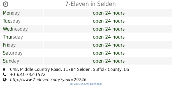
+1 631-736-1161
website:
www.7-eleven.com
Latitude:
40.8520741
, Longitude:
-73.0399478
larger map & directions
read more
nearest Convenience store
1.411 km
CVS
822 Middle Country Road, Selden
Convenience store
read more
1.522 km
Milk n Things
815 Middle Country Road, Selden
Convenience store
read more
1.522 km
Barn
2505, 815 Middle Country Road, Selden
Convenience store
read more
1.534 km
7-Eleven
648 Middle Country Road, Selden
Convenience store
read more
1.604 km
Rite Aid
229 Independence Plaza, Selden
Convenience store
read more
1.617 km
Middle Country Quality Food
729 Middle Country Road # 1, Selden
Convenience store
read more
1.776 km
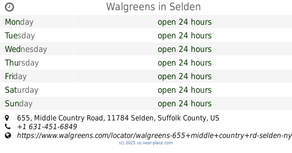
Walgreens
655 Middle Country Road, Selden
Convenience store
read more
1.946 km
7-Eleven
1316 Middle Country Road, Selden
Convenience store
read more
2.127 km
Portion Gasoline Convenience
1194 Portion Road, Holtsville
Convenience store
read more
2.265 km
Corner Wines & Liquors
711 Horseblock Road, Farmingville
Convenience store
read more
2.366 km
Corner Wine and Liquors
711 Horseblock Road, Store A, Farmingville
Convenience store
read more
3.019 km
Barn
1032 Portion Road, Farmingville
Convenience store
read more
3.133 km
Direct Marine Fuel
34 Barretts Avenue Unit #3, Holtsville
Convenience store
read more
3.301 km
Shell
1099 Horseblock Road, Farmingville
Gas station
Convenience store
Atm
Finance
Store
Food
Point of interest
Establishment
read more
3.404 km
7-Eleven
944 Portion Road, Ronkonkoma
Convenience store
read more
📑
all categories
Accounting
Administrative area level 1
Administrative area level 2
Airport
Amusement park
Aquarium
Art gallery
Atm
Bakery
Bank
Bar
Beauty salon
Bicycle store
Book store
Bowling alley
Bus station
Cafe
Campground
Car dealer
Car rental
Car repair
Car wash
Casino
Cemetery
Church
City hall
Clothing store
Colloquial area
Convenience store
Courthouse
Dentist
Department store
Doctor
Electrician
Electronics store
Embassy
Establishment
Finance
Fire station
Florist
Food
Funeral home
Furniture store
Gas station
General contractor
Grocery or supermarket
Gym
Hair care
Hardware store
Health
Hindu Temple
Home goods store
Hospital
Insurance agency
Intersection
Jewelry store
Laundry
Lawyer
Library
Light rail station
Liquor store
Local government office
Locality
Locksmith
Lodging
Meal delivery
Meal takeaway
Mosque
Movie rental
Movie theater
Moving company
Museum
Natural feature
Neighborhood
Night club
Painter
Park
Parking
Pet store
Pharmacy
Physiotherapist
Place of worship
Plumber
Point of interest
Police
Political
Post office
Premise
Real estate agency
Restaurant
Roofing contractor
Route
Rv park, camping
School
Shoe store
Shopping mall
Spa
Stadium
Storage
Store
Subpremise
Subway station
Supermarket
Synagogue
Taxi stand
Train station
Transit station
Travel agency
University
Veterinary care
Zoo
administrative area level 3
sublocality level 1
↑