Convenience store nearby 7-Eleven
United States
Convenience store nearby 7-Eleven
7-Eleven
3306 West Bell Rd, Phoenix United States
contacts phone
:
+1
Latitude:
33.6400908
, Longitude:
-112.1306431
read more
nearest Convenience store
1.517 km
Phoenix Mini Mart
4121 West Bell Road, Phoenix
Convenience store
read more
1.587 km
Circle K
3441 West Union Hills Drive, Phoenix
Convenience store
read more
1.704 km
Circle K
3502 West Union Hills Drive, Glendale
Convenience store
read more
1.733 km
Circle K
3449 West Greenway Road, Phoenix
Convenience store
read more
1.824 km
Puff N Pass Smoke Shop
2340 West Bell Road #126, Phoenix
Convenience store
read more
1.892 km
Circle K
4251 West Bell Road, Phoenix
Convenience store
read more
1.962 km
ampm
2711 West Union Hills Drive, Phoenix
Convenience store
read more
2.308 km
7-Eleven
2424 West Greenway Road, Phoenix
Convenience store
read more
2.446 km
Valero Corner Store
2409 West Union Hills Drive, Phoenix
Convenience store
read more
2.498 km
Circle K
2439 West Union Hills Drive, Phoenix
Convenience store
read more
3.296 km
Walgreens
18433 North 19th Avenue, Phoenix
Convenience store
read more
3.337 km
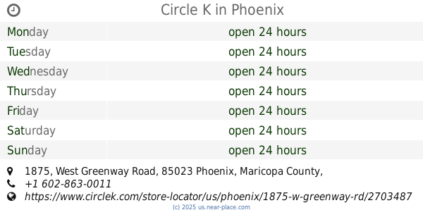
Circle K
1875 West Greenway Road, Phoenix
Convenience store
read more
3.371 km
Circle K
1850 West Union Hills Drive, Phoenix
Convenience store
read more
4.366 km
Brian's Discount Market
13648 North 19th Avenue, Phoenix
Convenience store
read more
5.364 km
Walgreens
5421 W Thunderbird Rd, Glendale
Convenience store
read more
📑
all categories
Accounting
Administrative area level 1
Administrative area level 2
Airport
Amusement park
Aquarium
Art gallery
Atm
Bakery
Bank
Bar
Beauty salon
Bicycle store
Book store
Bowling alley
Bus station
Cafe
Campground
Car dealer
Car rental
Car repair
Car wash
Casino
Cemetery
Church
City hall
Clothing store
Colloquial area
Convenience store
Courthouse
Dentist
Department store
Doctor
Electrician
Electronics store
Embassy
Establishment
Finance
Fire station
Florist
Food
Funeral home
Furniture store
Gas station
General contractor
Grocery or supermarket
Gym
Hair care
Hardware store
Health
Hindu Temple
Home goods store
Hospital
Insurance agency
Intersection
Jewelry store
Laundry
Lawyer
Library
Light rail station
Liquor store
Local government office
Locality
Locksmith
Lodging
Meal delivery
Meal takeaway
Mosque
Movie rental
Movie theater
Moving company
Museum
Natural feature
Neighborhood
Night club
Painter
Park
Parking
Pet store
Pharmacy
Physiotherapist
Place of worship
Plumber
Point of interest
Police
Political
Post office
Premise
Real estate agency
Restaurant
Roofing contractor
Route
Rv park, camping
School
Shoe store
Shopping mall
Spa
Stadium
Storage
Store
Subpremise
Subway station
Supermarket
Synagogue
Taxi stand
Train station
Transit station
Travel agency
University
Veterinary care
Zoo
administrative area level 3
sublocality level 1
↑