Convenience store nearby 7-Eleven
Coronavirus disease (COVID-19) Situation
confirmed cases
111820082
deaths
1219487
United States
Convenience store nearby 7-Eleven
7-Eleven
1080 Galloping Hill Road, Union Israel
contacts phone
:
+1
Latitude:
40.6767366
, Longitude:
-74.2672187
read more
nearest Convenience store
143 m
Rite Aid
327 Chestnut Street, Union
Convenience store
read more
1.147 km
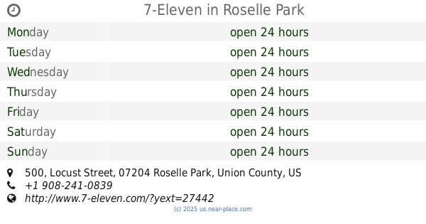
7-Eleven
500 Locust Street, Roselle Park
Convenience store
read more
1.334 km
CVS
1319 Magie Avenue, Union
Convenience store
read more
1.371 km
Foodland
340 Carnegie Avenue, Kenilworth
Convenience store
read more
1.638 km
Magie Convenience & Deli
1175 Magie Avenue, Union
Convenience store
read more
1.642 km
Ritchy Convenience Store
1175 Magie Avenue, Union
Convenience store
read more
1.762 km
One-Stop Shop
215 East Westfield Avenue, Roselle Park
Convenience store
read more
1.762 km
Super One Communications
215 East Westfield Avenue, Roselle Park
Convenience store
read more
1.769 km
Quick Stop Shop
215 East Westfield Avenue, Roselle Park
Convenience store
read more
1.831 km
CVS
107 East 1st Avenue, Roselle
Convenience store
read more
1.917 km
Walgreens
120 East 1st Avenue, Roselle
Convenience store
read more
1.966 km
S & W Convenient Store
121 Chestnut Street, Roselle
Convenience store
read more
2.119 km
QuickChek
1509 Morris Avenue, Union
Convenience store
read more
2.187 km
7-Eleven
555 East 1st Avenue, Roselle
Convenience store
read more
2.291 km
Krishna General Store
535 East 2nd Avenue, Roselle
Convenience store
read more
📑
all categories
Accounting
Administrative area level 1
Administrative area level 2
Airport
Amusement park
Aquarium
Art gallery
Atm
Bakery
Bank
Bar
Beauty salon
Bicycle store
Book store
Bowling alley
Bus station
Cafe
Campground
Car dealer
Car rental
Car repair
Car wash
Casino
Cemetery
Church
City hall
Clothing store
Colloquial area
Convenience store
Courthouse
Dentist
Department store
Doctor
Electrician
Electronics store
Embassy
Establishment
Finance
Fire station
Florist
Food
Funeral home
Furniture store
Gas station
General contractor
Grocery or supermarket
Gym
Hair care
Hardware store
Health
Hindu Temple
Home goods store
Hospital
Insurance agency
Intersection
Jewelry store
Laundry
Lawyer
Library
Light rail station
Liquor store
Local government office
Locality
Locksmith
Lodging
Meal delivery
Meal takeaway
Mosque
Movie rental
Movie theater
Moving company
Museum
Natural feature
Neighborhood
Night club
Painter
Park
Parking
Pet store
Pharmacy
Physiotherapist
Place of worship
Plumber
Point of interest
Police
Political
Post office
Premise
Real estate agency
Restaurant
Roofing contractor
Route
Rv park, camping
School
Shoe store
Shopping mall
Spa
Stadium
Storage
Store
Subpremise
Subway station
Supermarket
Synagogue
Taxi stand
Train station
Transit station
Travel agency
University
Veterinary care
Zoo
administrative area level 3
sublocality level 1
↑