Cafe nearby Dunkin' Donuts
United States
Cafe nearby Dunkin' Donuts
Dunkin' Donuts
1326 West Anaheim Street, Wilmington United States
contacts phone
:
+1
Latitude:
33.7789348
, Longitude:
-118.2791357
read more
nearest Cafe
1.715 km
Boba Fresca
435 West Pacific Coast Highway, Wilmington
Cafe
read more
1.746 km
Estela's Restaurant
401 West Pacific Coast Highway, Wilmington
Cafe
read more
1.765 km
tea lovers and juices
401 West Pacific Coast Highway, Wilmington
Cafe
read more
2.155 km
McDonald's
230 East Pacific Coast Highway, Wilmington
Cafe
read more
3.478 km
Starbucks
651 West Sepulveda Boulevard, Carson
Cafe
Store
Food
Point of interest
Establishment
read more
3.495 km
Starbucks
651 Sepulveda Boulevard, Carson
Cafe
read more
3.567 km
Starbucks
The Makena Vermont Retail Center, 898 Sepulveda Boulevard, West Carson
Cafe
Restaurant
Food
Store
Point of interest
Establishment
read more
3.573 km
Starbucks
898 Sepulveda Blvd, Harbor City
Cafe
read more
3.722 km
McDonald's
931 Sepulveda Boulevard, Torrance
Cafe
read more
4.452 km
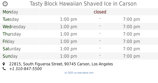
Tasty Block Hawaiian Shaved Ice
22815 South Figueroa Street, Carson
Cafe
Food
Point of interest
Store
Establishment
read more
4.891 km
Starbucks Drive-thru
3108, 682 West 9th Street, San Pedro
Cafe
read more
16.189 km
NORMS Restaurant
17844 Lakewood Boulevard, Bellflower
Restaurant
Cafe
Food
Point of interest
Establishment
read more
16.556 km
Starbucks
17254 Lakewood Boulevard, Bellflower
Cafe
Restaurant
Food
Store
Point of interest
Establishment
read more
18 km
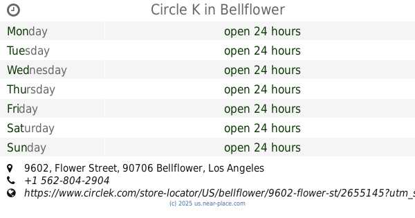
Circle K
9602 Flower Street, Bellflower
Convenience store
Cafe
Meal takeaway
Restaurant
Food
Store
Point of interest
Establishment
read more
18.227 km
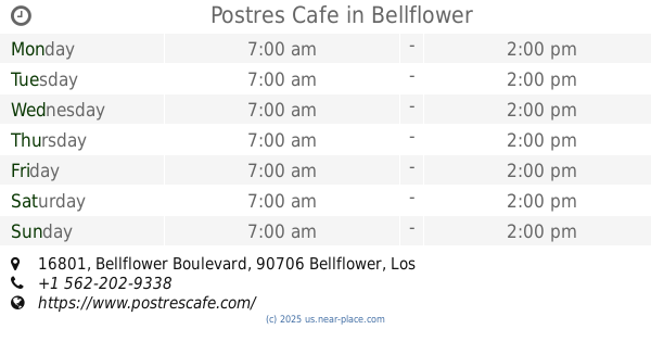
Postres Cafe
16801 Bellflower Boulevard, Bellflower
Cafe
Store
Restaurant
Food
Point of interest
Establishment
read more
📑
all categories
Accounting
Administrative area level 1
Administrative area level 2
Airport
Amusement park
Aquarium
Art gallery
Atm
Bakery
Bank
Bar
Beauty salon
Bicycle store
Book store
Bowling alley
Bus station
Cafe
Campground
Car dealer
Car rental
Car repair
Car wash
Casino
Cemetery
Church
City hall
Clothing store
Colloquial area
Convenience store
Courthouse
Dentist
Department store
Doctor
Electrician
Electronics store
Embassy
Establishment
Finance
Fire station
Florist
Food
Funeral home
Furniture store
Gas station
General contractor
Grocery or supermarket
Gym
Hair care
Hardware store
Health
Hindu Temple
Home goods store
Hospital
Insurance agency
Intersection
Jewelry store
Laundry
Lawyer
Library
Light rail station
Liquor store
Local government office
Locality
Locksmith
Lodging
Meal delivery
Meal takeaway
Mosque
Movie rental
Movie theater
Moving company
Museum
Natural feature
Neighborhood
Night club
Painter
Park
Parking
Pet store
Pharmacy
Physiotherapist
Place of worship
Plumber
Point of interest
Police
Political
Post office
Premise
Real estate agency
Restaurant
Roofing contractor
Route
Rv park, camping
School
Shoe store
Shopping mall
Spa
Stadium
Storage
Store
Subpremise
Subway station
Supermarket
Synagogue
Taxi stand
Train station
Transit station
Travel agency
University
Veterinary care
Zoo
administrative area level 3
sublocality level 1
↑