Bus station nearby Salesforce Transit Center
United States
Bus station nearby Salesforce Transit Center
Salesforce Transit Center
San Francisco, California 94105, EE. UU.
contacts phone
:
+1
Latitude:
37.790439
, Longitude:
-122.395183
larger map & directions
read more
nearest Bus station
109 m
Howard St & Fremont St
United States
Bus station
read more
210 m
Transbay Temp Terminal
United States
Bus station
read more
211 m
Beale St & Mission St
United States
Bus station
read more
218 m
Beale St btwn Market St & Mission St
United States
Bus station
read more
259 m
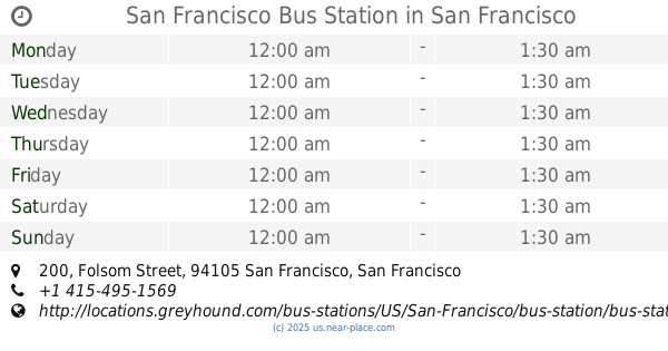
San Francisco Bus Station
200 Folsom Street, San Francisco
Bus station
read more
264 m
Hward St&Spear
United States
Bus station
read more
447 m
Davis St & California St
San Francisco
Bus station
read more
473 m
Sansome St & Sutter St
San Francisco
Bus station
read more
485 m
Market St & Sansome St
United States
Bus station
read more
502 m
Sacramento St & Davis St
United States
Bus station
read more
528 m
Folsom St & 2nd St
San Francisco
Bus station
read more
618 m
Sansome St & California St
United States
Bus station
read more
620 m
Clay St & Front St
United States
Bus station
read more
692 m
Sansome St & Sacramento St
San Francisco
Bus station
read more
705 m
2nd St & Harrison St
United States
Bus station
read more
755 m
Kearny St & Sutter St
United States
Bus station
read more
757 m
Sansome St & Clay St
San Francisco
Bus station
read more
768 m
Kearny St & Geary St
United States
Bus station
read more
897 m
Sansome St & Jackson St
United States
Bus station
read more
916 m
Harrison St & 3rd St
United States
Bus station
read more
939 m
3rd St & Perry St
San Francisco
Bus station
read more
972 m
Post St & Grant Ave
United States
Bus station
read more
999 m
2nd St & Brannan St
United States
Bus station
read more
1.171 km
Kearny St & Pacific Ave
United States
Bus station
read more
1.211 km
Columbus Ave & Kearny St
United States
Bus station
read more
📑
all categories
Accounting
Administrative area level 1
Administrative area level 2
Airport
Amusement park
Aquarium
Art gallery
Atm
Bakery
Bank
Bar
Beauty salon
Bicycle store
Book store
Bowling alley
Bus station
Cafe
Campground
Car dealer
Car rental
Car repair
Car wash
Casino
Cemetery
Church
City hall
Clothing store
Colloquial area
Convenience store
Courthouse
Dentist
Department store
Doctor
Electrician
Electronics store
Embassy
Establishment
Finance
Fire station
Florist
Food
Funeral home
Furniture store
Gas station
General contractor
Grocery or supermarket
Gym
Hair care
Hardware store
Health
Hindu Temple
Home goods store
Hospital
Insurance agency
Intersection
Jewelry store
Laundry
Lawyer
Library
Light rail station
Liquor store
Local government office
Locality
Locksmith
Lodging
Meal delivery
Meal takeaway
Mosque
Movie rental
Movie theater
Moving company
Museum
Natural feature
Neighborhood
Night club
Painter
Park
Parking
Pet store
Pharmacy
Physiotherapist
Place of worship
Plumber
Point of interest
Police
Political
Post office
Premise
Real estate agency
Restaurant
Roofing contractor
Route
Rv park, camping
School
Shoe store
Shopping mall
Spa
Stadium
Storage
Store
Subpremise
Subway station
Supermarket
Synagogue
Taxi stand
Train station
Transit station
Travel agency
University
Veterinary care
Zoo
administrative area level 3
sublocality level 1
↑