Bank nearby Chase Bank
United States
Bank nearby Chase Bank
Chase Bank
5407 N I H 35, Austin, TX 78723, USA
contacts phone
:
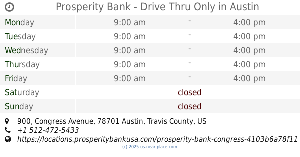
+1 512-371-5350
website:
locator.chase.com
Latitude:
30.314318
, Longitude:
-97.706931
larger map & directions
read more
nearest Bank
837 m
Platinum Processing Services
1106 Clayton Lane # 105E, Austin
Bank
read more
875 m
Frost Bank
1200 Barbara Jordan Boulevard, Austin
Bank
read more
891 m
Wells Fargo Bank
1201 Barbara Jordan Blvd, Bldg 10, Austin
Bank
read more
1.115 km
Farm Credit Bank of Texas
6210 U.S. 290 Frontage Road, Austin
Bank
read more
2.338 km
Wells Fargo Bank
3909 N I H 35, Austin
Bank
read more
3.228 km
Woodforest National Bank
1030 Norwood Park Boulevard, Austin
Bank
read more
4.994 km
ATM 7ELEVEN, INC.
411 West Martin Luther King Junior Boulevard, Austin
Atm
Bank
Finance
Point of interest
Establishment
read more
5.447 km
Wells Fargo Bank
605 West 15th Street, Austin
Bank
Atm
Finance
Point of interest
Establishment
read more
5.601 km
Novel
316 West 12th Street 6th Floor, Austin
Bank
Finance
Point of interest
Establishment
read more
5.742 km
Texas Regional Bank
1001 Congress Avenue Suite 150, Austin
Bank
Finance
Point of interest
Establishment
read more
5.815 km
Prosperity Bank
206 East 9th Street, Austin
Bank
Atm
Finance
Point of interest
Establishment
read more
5.863 km
Prosperity Bank - Drive Thru Only
900 Congress Avenue, Austin
Bank
Atm
Finance
Point of interest
Establishment
read more
6.177 km
ATM 7ELEVEN, INC.
917 North Lamar Boulevard, Austin
Bank
Finance
Point of interest
Establishment
read more
6.667 km
VeraBank
1111 West 6th Street Bldg B Suite 200, Austin
Bank
Finance
Point of interest
Establishment
read more
6.746 km
Vera Bank
United States
Bank
Finance
Point of interest
Establishment
read more
📑
all categories
Accounting
Administrative area level 1
Administrative area level 2
Airport
Amusement park
Aquarium
Art gallery
Atm
Bakery
Bank
Bar
Beauty salon
Bicycle store
Book store
Bowling alley
Bus station
Cafe
Campground
Car dealer
Car rental
Car repair
Car wash
Casino
Cemetery
Church
City hall
Clothing store
Colloquial area
Convenience store
Courthouse
Dentist
Department store
Doctor
Electrician
Electronics store
Embassy
Establishment
Finance
Fire station
Florist
Food
Funeral home
Furniture store
Gas station
General contractor
Grocery or supermarket
Gym
Hair care
Hardware store
Health
Hindu Temple
Home goods store
Hospital
Insurance agency
Intersection
Jewelry store
Laundry
Lawyer
Library
Light rail station
Liquor store
Local government office
Locality
Locksmith
Lodging
Meal delivery
Meal takeaway
Mosque
Movie rental
Movie theater
Moving company
Museum
Natural feature
Neighborhood
Night club
Painter
Park
Parking
Pet store
Pharmacy
Physiotherapist
Place of worship
Plumber
Point of interest
Police
Political
Post office
Premise
Real estate agency
Restaurant
Roofing contractor
Route
Rv park, camping
School
Shoe store
Shopping mall
Spa
Stadium
Storage
Store
Subpremise
Subway station
Supermarket
Synagogue
Taxi stand
Train station
Transit station
Travel agency
University
Veterinary care
Zoo
administrative area level 3
sublocality level 1
↑