Bank nearby Bank of America Financial Center
United States
Bank nearby Bank of America Financial Center
Bank of America Financial Center
15 Bennetts Road, Setauket- East Setauket Israel
contacts phone
:
+1
Latitude:
40.9296663
, Longitude:
-73.1148157
read more
nearest Bank
63 m
Gold Coast Bank
690 New York 25A, Setauket- East Setauket
Bank
read more
720 m
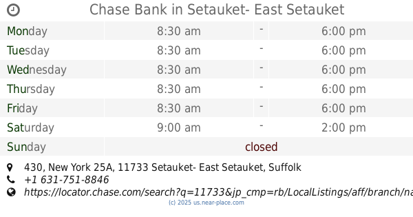
Chase Bank
430 New York 25A, Setauket- East Setauket
Bank
read more
807 m
Chase Bank
1395 New York 25A, Setauket- East Setauket
Bank
read more
877 m
Bank of New York Mellon
3 Village Shopping Ctr, Setauket- East Setauket
Bank
read more
1.199 km
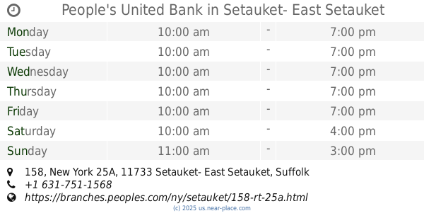
People's United Bank
158 New York 25A, Setauket- East Setauket
Bank
read more
1.3 km
ATM 7ELEVEN, INC.
1001 New York 25A, Stony Brook
Bank
read more
1.371 km
Capital One Bank
61 New York 25A, Setauket- East Setauket
Bank
read more
1.456 km
Apple Bank
10 New York 25A, Setauket- East Setauket
Bank
read more
1.476 km
Sterling National Bank
Rt. 25A, 1047 North Country Road, Stony Brook
Bank
read more
1.911 km
HSBC Bank
300 Main Street #1, Setauket- East Setauket
Bank
read more
4.02 km
People's United Bank
135 West Broadway, Port Jefferson
Bank
read more
4.274 km
BNB Bank
414 Main Street Suite 103/104, Port Jefferson
Bank
read more
4.381 km
People's United Bank
228 East Main Street, Port Jefferson
Bank
read more
4.81 km
Capital One Bank
532 Old Town Road, Port Jefferson Station
Bank
read more
4.834 km
TD Bank
86 W Nesconset Highway, Port Jefferson Station
Bank
read more
📑
all categories
Accounting
Administrative area level 1
Administrative area level 2
Airport
Amusement park
Aquarium
Art gallery
Atm
Bakery
Bank
Bar
Beauty salon
Bicycle store
Book store
Bowling alley
Bus station
Cafe
Campground
Car dealer
Car rental
Car repair
Car wash
Casino
Cemetery
Church
City hall
Clothing store
Colloquial area
Convenience store
Courthouse
Dentist
Department store
Doctor
Electrician
Electronics store
Embassy
Establishment
Finance
Fire station
Florist
Food
Funeral home
Furniture store
Gas station
General contractor
Grocery or supermarket
Gym
Hair care
Hardware store
Health
Hindu Temple
Home goods store
Hospital
Insurance agency
Intersection
Jewelry store
Laundry
Lawyer
Library
Light rail station
Liquor store
Local government office
Locality
Locksmith
Lodging
Meal delivery
Meal takeaway
Mosque
Movie rental
Movie theater
Moving company
Museum
Natural feature
Neighborhood
Night club
Painter
Park
Parking
Pet store
Pharmacy
Physiotherapist
Place of worship
Plumber
Point of interest
Police
Political
Post office
Premise
Real estate agency
Restaurant
Roofing contractor
Route
Rv park, camping
School
Shoe store
Shopping mall
Spa
Stadium
Storage
Store
Subpremise
Subway station
Supermarket
Synagogue
Taxi stand
Train station
Transit station
Travel agency
University
Veterinary care
Zoo
administrative area level 3
sublocality level 1
↑