Bank nearby ATM 7ELEVEN, INC.
United States
Bank nearby ATM 7ELEVEN, INC.
ATM 7ELEVEN, INC.
4180, East Sahara Avenue, 89104, Las Vegas, Clark County, US United States
contacts phone
:
+1 800-627-3999
Latitude:
36.1447548
, Longitude:
-115.0834545
larger map & directions
read more
nearest Bank
1.446 km
Bank of America Financial Center
4945 East Sahara Avenue, Las Vegas
Bank
read more
1.524 km
Wells Fargo Bank
4215 East Charleston Boulevard, Las Vegas
Bank
read more
1.535 km
Bank of America Financial Center
4111 E Charleston Blvd, Las Vegas
Bank
read more
1.535 km
Bank of America Financial Center
4111 East Charleston Boulevard, Las Vegas
Bank
read more
1.541 km
ATM 7ELEVEN, INC.
4151 Boulder Highway, Las Vegas
Bank
read more
1.666 km
Wells Fargo Bank
2875 South Nellis Boulevard Ste 10, Las Vegas
Bank
read more
1.807 km
ATM 7ELEVEN, INC.
2919 South Nellis Boulevard, Las Vegas
Bank
read more
2.32 km
One Nevada Credit Union
1292 South Nellis Boulevard Ste C, Las Vegas
Bank
read more
2.494 km
ATM Hammerheads
3310 South Nellis Boulevard, Las Vegas
Bank
read more
2.826 km
Westbank Inc
3225 McLeod Drive, Las Vegas
Bank
read more
2.834 km
Braewood Heritage Homeowners
3570 South Braewood Drive, Las Vegas
Bank
read more
2.977 km
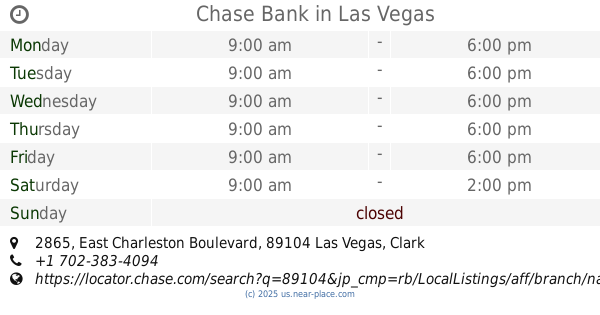
Chase Bank
2865 East Charleston Boulevard, Las Vegas
Bank
read more
3.079 km
U.S. Bank Branch
2885 East Desert Inn Road, Las Vegas
Bank
read more
3.214 km
California Federal Bank
2625 East Desert Inn Road, Las Vegas
Bank
read more
3.306 km
Chase Bank
520 North Nellis Boulevard, Las Vegas
Bank
read more
📑
all categories
Accounting
Administrative area level 1
Administrative area level 2
Airport
Amusement park
Aquarium
Art gallery
Atm
Bakery
Bank
Bar
Beauty salon
Bicycle store
Book store
Bowling alley
Bus station
Cafe
Campground
Car dealer
Car rental
Car repair
Car wash
Casino
Cemetery
Church
City hall
Clothing store
Colloquial area
Convenience store
Courthouse
Dentist
Department store
Doctor
Electrician
Electronics store
Embassy
Establishment
Finance
Fire station
Florist
Food
Funeral home
Furniture store
Gas station
General contractor
Grocery or supermarket
Gym
Hair care
Hardware store
Health
Hindu Temple
Home goods store
Hospital
Insurance agency
Intersection
Jewelry store
Laundry
Lawyer
Library
Light rail station
Liquor store
Local government office
Locality
Locksmith
Lodging
Meal delivery
Meal takeaway
Mosque
Movie rental
Movie theater
Moving company
Museum
Natural feature
Neighborhood
Night club
Painter
Park
Parking
Pet store
Pharmacy
Physiotherapist
Place of worship
Plumber
Point of interest
Police
Political
Post office
Premise
Real estate agency
Restaurant
Roofing contractor
Route
Rv park, camping
School
Shoe store
Shopping mall
Spa
Stadium
Storage
Store
Subpremise
Subway station
Supermarket
Synagogue
Taxi stand
Train station
Transit station
Travel agency
University
Veterinary care
Zoo
administrative area level 3
sublocality level 1
↑