Bakery nearby Pettit's Pastry
United States
Bakery nearby Pettit's Pastry
Pettit's Pastry
502, North 16th Street, 68102, Omaha, Douglas County, US United States
contacts phone
:
+1 402-345-1111
Latitude:
41.264109
, Longitude:
-95.9374712
larger map & directions
read more
nearest Bakery
643 m
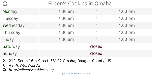
Eileen's Cookies
210 South 16th Street, Omaha
Bakery
read more
1.034 km
Wheatfields Express
1202 Howard Street, Omaha
Bakery
read more
1.11 km
13th Street Coffee and Tea - The Original Omaha Coffee And Tea Shop
519 South 13th Street, Omaha
Night club
Bar
Cafe
Bakery
Food
Point of interest
Store
Establishment
read more
1.116 km
Nicola's Italian Wine & Fare
521 South 13th Street, Omaha
Bakery
read more
1.139 km
Cupcake Omaha
501 South 11th Street, Omaha
Bakery
read more
1.151 km
Chris Janicek's Cake Box
501 South 11th Street, Omaha
Bakery
read more
1.984 km
Orsi's Italian Bakery & Pizzeria
621 Pacific Street, Omaha
Bakery
read more
2.02 km
Donut Stop
1256 South 13th Street, Omaha
Bakery
read more
2.063 km
Cold Stone Creamery & Rocky Mountain Chocolate Factory
3220 Farnam Street ste 2107, Omaha
Bakery
read more
2.284 km
Panaderia Espiga De Oro
1052 Park Avenue, Omaha
Bakery
read more
2.489 km
Olsen Bake Shop
1708 South 10th Street, Omaha
Bakery
read more
2.598 km
Panaderia de Las Americas
1344 Park Avenue, Omaha
Bakery
read more
2.809 km
Eat Bob's Donuts
3114, 3824 Farnam Street suite 122, Omaha
Bakery
read more
2.813 km
Bob's Donuts
Omaha
Bakery
read more
2.97 km
Sweet Magnolias Bake Shop
813 North 40th Street, Omaha
Bakery
read more
📑
all categories
Accounting
Administrative area level 1
Administrative area level 2
Airport
Amusement park
Aquarium
Art gallery
Atm
Bakery
Bank
Bar
Beauty salon
Bicycle store
Book store
Bowling alley
Bus station
Cafe
Campground
Car dealer
Car rental
Car repair
Car wash
Casino
Cemetery
Church
City hall
Clothing store
Colloquial area
Convenience store
Courthouse
Dentist
Department store
Doctor
Electrician
Electronics store
Embassy
Establishment
Finance
Fire station
Florist
Food
Funeral home
Furniture store
Gas station
General contractor
Grocery or supermarket
Gym
Hair care
Hardware store
Health
Hindu Temple
Home goods store
Hospital
Insurance agency
Intersection
Jewelry store
Laundry
Lawyer
Library
Light rail station
Liquor store
Local government office
Locality
Locksmith
Lodging
Meal delivery
Meal takeaway
Mosque
Movie rental
Movie theater
Moving company
Museum
Natural feature
Neighborhood
Night club
Painter
Park
Parking
Pet store
Pharmacy
Physiotherapist
Place of worship
Plumber
Point of interest
Police
Political
Post office
Premise
Real estate agency
Restaurant
Roofing contractor
Route
Rv park, camping
School
Shoe store
Shopping mall
Spa
Stadium
Storage
Store
Subpremise
Subway station
Supermarket
Synagogue
Taxi stand
Train station
Transit station
Travel agency
University
Veterinary care
Zoo
administrative area level 3
sublocality level 1
↑