Atm nearby Payment Alliance International, Inc.
Coronavirus disease (COVID-19) Situation
confirmed cases
111820082
deaths
1219487
United States
Atm nearby Payment Alliance International, Inc.
Payment Alliance International, Inc.
4100, Bryan Street, 75204, Dallas, Dallas County, US United States
contacts phone
:
+1
website:
www.gopai.com
Latitude:
32.7976302
, Longitude:
-96.7804359
larger map & directions
read more
nearest Atm
11 m
ATM
4100 Bryan Street, Dallas
Atm
read more
309 m
ATM 7ELEVEN, INC.
1621 North Haskell Avenue, Dallas
Atm
read more
336 m
ATM
4314 Live Oak Street, Dallas
Atm
read more
341 m
Citibank ATM
1621 North Haskell Avenue, Dallas
Atm
read more
370 m
RockItCoin Bitcoin ATM
4423 Live Oak Street, Dallas
Atm
read more
373 m
Cardtronics ATM
4423 Live Oak Street, Dallas
Atm
read more
481 m
Capital One ATM
4111 Gaston Avenue, Dallas
Atm
read more
489 m
ATM (Capital One Bank)
4111 Gaston Avenue, Dallas
Atm
read more
520 m
ATM (Bank of America)
3921 Gaston Avenue, Dallas
Atm
read more
837 m
Credit Union of Texas
3305 Ross Avenue, Dallas
Atm
read more
876 m
ATM (Chase Bank)
4709 Ross Avenue, Dallas
Atm
read more
898 m
Atm
3302 Gaston Avenue, Dallas
Atm
read more
1.029 km
ATM Link
4825 Ross Avenue, Dallas
Atm
read more
1.08 km
ATM Network, Inc.
2305 Washington St, Dallas
Atm
read more
1.098 km
ACE Cash Express - ATM
2821 Live Oak Street, Dallas
Atm
read more
1.147 km
Payment Alliance International, Inc.
Dallas
Atm
read more
1.214 km
ATM (7-Eleven)
2503 Lemmon Avenue, Dallas
Atm
read more
1.242 km
ATM (Bank of America)
2500 North Haskell Avenue, Dallas
Atm
read more
1.506 km
Automated Financial, LLC
2639 Elm Street, Dallas
Atm
read more
1.644 km
Cardtronics
5329 Ross Avenue, Dallas
Atm
read more
1.83 km
UMB Bank
2323 Ross Avenue #100, Dallas
Atm
read more
1.879 km
ATM
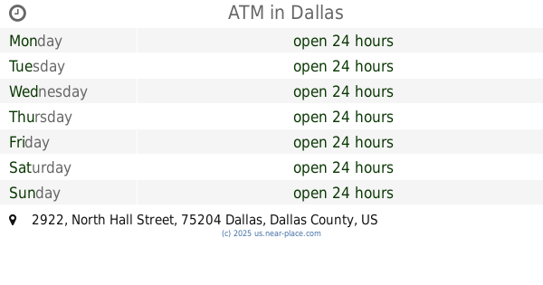
2922 North Hall Street, Dallas
Atm
read more
2.003 km
Access to Money
2801 North Fitzhugh Avenue, Dallas
Atm
read more
2.272 km
Chase ATM
Dallas
Atm
read more
2.452 km
ATM Express
1618 Main Street, Dallas
Atm
read more
📑
all categories
Accounting
Administrative area level 1
Administrative area level 2
Airport
Amusement park
Aquarium
Art gallery
Atm
Bakery
Bank
Bar
Beauty salon
Bicycle store
Book store
Bowling alley
Bus station
Cafe
Campground
Car dealer
Car rental
Car repair
Car wash
Casino
Cemetery
Church
City hall
Clothing store
Colloquial area
Convenience store
Courthouse
Dentist
Department store
Doctor
Electrician
Electronics store
Embassy
Establishment
Finance
Fire station
Florist
Food
Funeral home
Furniture store
Gas station
General contractor
Grocery or supermarket
Gym
Hair care
Hardware store
Health
Hindu Temple
Home goods store
Hospital
Insurance agency
Intersection
Jewelry store
Laundry
Lawyer
Library
Light rail station
Liquor store
Local government office
Locality
Locksmith
Lodging
Meal delivery
Meal takeaway
Mosque
Movie rental
Movie theater
Moving company
Museum
Natural feature
Neighborhood
Night club
Painter
Park
Parking
Pet store
Pharmacy
Physiotherapist
Place of worship
Plumber
Point of interest
Police
Political
Post office
Premise
Real estate agency
Restaurant
Roofing contractor
Route
Rv park, camping
School
Shoe store
Shopping mall
Spa
Stadium
Storage
Store
Subpremise
Subway station
Supermarket
Synagogue
Taxi stand
Train station
Transit station
Travel agency
University
Veterinary care
Zoo
administrative area level 3
sublocality level 1
↑