Atm nearby ATM (Signature Austin)
United States
Atm nearby ATM (Signature Austin)
ATM (Signature Austin)
608 South Lamar Boulevard, Austin Vereinigte Staaten
contacts phone
:
+1
Latitude:
30.2591846
, Longitude:
-97.7592936
read more
nearest Atm
255 m
Universal ATM Network
700 Dawson Road, Austin
Atm
read more
326 m
Cardtronics ATM
1525 Barton Springs Road, Austin
Atm
read more
635 m
Velocity Credit Union (Palmer Events Center ATM)
900 Barton Springs Road, Austin
Atm
read more
706 m
Velocity Credit Union (Austin Energy ATM)
721 Barton Springs Road, Austin
Atm
read more
820 m
Citibank ATM
1403 South Lamar Boulevard, Austin
Atm
read more
1.244 km
Wells Fargo ATM
501 South Congress Avenue, Austin
Atm
Finance
Point of interest
Establishment
read more
1.437 km
Guaranty Bank & Trust in Austin, Texas
601 West 5th Street, Austin
Bank
Atm
Finance
Point of interest
Establishment
read more
1.667 km
PNC Bank
301 Congress Avenue Ste 150, Austin
Bank
Atm
Finance
Point of interest
Establishment
read more
1.827 km
PNC Bank
1703 West 5th Street Ste 100, Austin
Bank
Atm
Finance
Point of interest
Establishment
read more
1.864 km
Bank of America ATM
515 Congress Avenue, Austin
Atm
Finance
Point of interest
Establishment
read more
1.872 km
Horizon Bank
600 Congress Avenue suite g-260, Austin
Bank
Atm
Finance
Point of interest
Establishment
read more
2.128 km
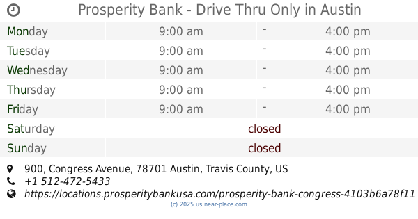
Prosperity Bank - Drive Thru Only
900 Congress Avenue, Austin
Bank
Atm
Finance
Point of interest
Establishment
read more
2.132 km
ATM
606 Trinity Street, Austin
Atm
Finance
Point of interest
Establishment
read more
2.239 km
Prosperity Bank
206 East 9th Street, Austin
Bank
Atm
Finance
Point of interest
Establishment
read more
2.408 km
Texas A&M University System State Relations
1303 San Antonio Street #850, Austin
Atm
Local government office
Finance
Point of interest
Establishment
read more
📑
all categories
Accounting
Administrative area level 1
Administrative area level 2
Airport
Amusement park
Aquarium
Art gallery
Atm
Bakery
Bank
Bar
Beauty salon
Bicycle store
Book store
Bowling alley
Bus station
Cafe
Campground
Car dealer
Car rental
Car repair
Car wash
Casino
Cemetery
Church
City hall
Clothing store
Colloquial area
Convenience store
Courthouse
Dentist
Department store
Doctor
Electrician
Electronics store
Embassy
Establishment
Finance
Fire station
Florist
Food
Funeral home
Furniture store
Gas station
General contractor
Grocery or supermarket
Gym
Hair care
Hardware store
Health
Hindu Temple
Home goods store
Hospital
Insurance agency
Intersection
Jewelry store
Laundry
Lawyer
Library
Light rail station
Liquor store
Local government office
Locality
Locksmith
Lodging
Meal delivery
Meal takeaway
Mosque
Movie rental
Movie theater
Moving company
Museum
Natural feature
Neighborhood
Night club
Painter
Park
Parking
Pet store
Pharmacy
Physiotherapist
Place of worship
Plumber
Point of interest
Police
Political
Post office
Premise
Real estate agency
Restaurant
Roofing contractor
Route
Rv park, camping
School
Shoe store
Shopping mall
Spa
Stadium
Storage
Store
Subpremise
Subway station
Supermarket
Synagogue
Taxi stand
Train station
Transit station
Travel agency
University
Veterinary care
Zoo
administrative area level 3
sublocality level 1
↑