Atm nearby ATM
United States
Atm nearby ATM
ATM
2700 West Anderson Lane, Austin United States
contacts phone
:
+1
Latitude:
30.3586379
, Longitude:
-97.7349222
read more
nearest Atm
4.849 km
ATM
1030 Norwood Park Boulevard # 2, Austin
Atm
read more
4.913 km
ATM Express
909 East Koenig Lane, Austin
Atm
read more
5.045 km
ATM
6210 U.S. 290 Frontage Road, Austin
Atm
read more
5.184 km
International Merchant Services (P
500 East 51st Street, Austin
Atm
read more
5.615 km
Chase ATM#3976
5403 North Interstate Highway 35, Austin
Atm
read more
7.65 km
UFCU ATM (Limited Access)
100 West Dean Keeton Street 1st floor, Austin
Atm
Finance
Point of interest
Establishment
read more
8.252 km
ATM
709 West 22nd Street STE 200, Austin
Atm
Finance
Point of interest
Establishment
read more
8.436 km
UFCU ATM (Limited Access)
201 East 21st Street, Austin
Atm
Finance
Point of interest
Establishment
read more
8.981 km
ATM (Wells Fargo Bank)
601 West 15th Street, Austin
Atm
Finance
Point of interest
Establishment
read more
9.751 km
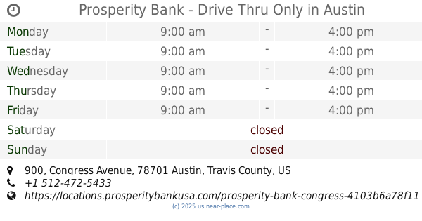
Prosperity Bank - Drive Thru Only
900 Congress Avenue, Austin
Bank
Atm
Finance
Point of interest
Establishment
read more
9.775 km
PNC Bank
1703 West 5th Street Ste 100, Austin
Bank
Atm
Finance
Point of interest
Establishment
read more
9.81 km
Prosperity Bank
206 East 9th Street, Austin
Bank
Atm
Finance
Point of interest
Establishment
read more
10.133 km
Bank of America ATM
515 Congress Avenue, Austin
Atm
Finance
Point of interest
Establishment
read more
10.211 km
ATM
606 Trinity Street, Austin
Atm
Finance
Point of interest
Establishment
read more
10.393 km
PNC Bank
301 Congress Avenue Ste 150, Austin
Bank
Atm
Finance
Point of interest
Establishment
read more
📑
all categories
Accounting
Administrative area level 1
Administrative area level 2
Airport
Amusement park
Aquarium
Art gallery
Atm
Bakery
Bank
Bar
Beauty salon
Bicycle store
Book store
Bowling alley
Bus station
Cafe
Campground
Car dealer
Car rental
Car repair
Car wash
Casino
Cemetery
Church
City hall
Clothing store
Colloquial area
Convenience store
Courthouse
Dentist
Department store
Doctor
Electrician
Electronics store
Embassy
Establishment
Finance
Fire station
Florist
Food
Funeral home
Furniture store
Gas station
General contractor
Grocery or supermarket
Gym
Hair care
Hardware store
Health
Hindu Temple
Home goods store
Hospital
Insurance agency
Intersection
Jewelry store
Laundry
Lawyer
Library
Light rail station
Liquor store
Local government office
Locality
Locksmith
Lodging
Meal delivery
Meal takeaway
Mosque
Movie rental
Movie theater
Moving company
Museum
Natural feature
Neighborhood
Night club
Painter
Park
Parking
Pet store
Pharmacy
Physiotherapist
Place of worship
Plumber
Point of interest
Police
Political
Post office
Premise
Real estate agency
Restaurant
Roofing contractor
Route
Rv park, camping
School
Shoe store
Shopping mall
Spa
Stadium
Storage
Store
Subpremise
Subway station
Supermarket
Synagogue
Taxi stand
Train station
Transit station
Travel agency
University
Veterinary care
Zoo
administrative area level 3
sublocality level 1
↑