Airport nearby Quaker Valley Farm
United States
Airport nearby Quaker Valley Farm
Quaker Valley Farm
Pawling Израиль
contacts phone
:
+1
Latitude:
41.5974999
, Longitude:
-73.5315
read more
nearest Airport
2.06 km
Hammersley Hill
Pawling
Airport
read more
8.842 km
South Quaker
Pawling
Airport
read more
17.749 km
Yellow Express Car Service
19 Longfellow Drive, Carmel Hamlet
Airport
read more
18.17 km
Sherman Field
Lagrangeville
Airport
read more
20.828 km
Аэропорт Скай Эйкерс
30 Airway Drive, Lagrangeville
Airport
read more
22.539 km
Hospital Helipad
95 Locust Avenue, Danbury
Airport
read more
23.423 km
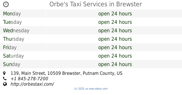
Orbe's Taxi Services
139 Main Street, Brewster
Airport
read more
25.216 km
Business Aircraft Center
81 Kenosia Avenue, Danbury
Airport
read more
29.428 km
Helipad
Mahopac
Airport
read more
36.122 km
Meier NDB PO 403
Marlboro
Airport
read more
38.761 km
Аэропорт Эрхейвен
Hyde Park
Airport
read more
41.152 km
Harris Hill Heliport
Bedford Hills
Airport
read more
45.918 km
Old Orchard Airpark-2NK9
Freetown Hwy , Highland, NY 12528, Wallkill
Airport
read more
48.497 km
Signature Flight Support SWF - Stewart Int'l Airport
1188 1st Street, New Windsor
Airport
read more
49.271 km
Westchester Resco Heliport
Peekskill
Airport
read more
📑
all categories
Accounting
Administrative area level 1
Administrative area level 2
Airport
Amusement park
Aquarium
Art gallery
Atm
Bakery
Bank
Bar
Beauty salon
Bicycle store
Book store
Bowling alley
Bus station
Cafe
Campground
Car dealer
Car rental
Car repair
Car wash
Casino
Cemetery
Church
City hall
Clothing store
Colloquial area
Convenience store
Courthouse
Dentist
Department store
Doctor
Electrician
Electronics store
Embassy
Establishment
Finance
Fire station
Florist
Food
Funeral home
Furniture store
Gas station
General contractor
Grocery or supermarket
Gym
Hair care
Hardware store
Health
Hindu Temple
Home goods store
Hospital
Insurance agency
Intersection
Jewelry store
Laundry
Lawyer
Library
Light rail station
Liquor store
Local government office
Locality
Locksmith
Lodging
Meal delivery
Meal takeaway
Mosque
Movie rental
Movie theater
Moving company
Museum
Natural feature
Neighborhood
Night club
Painter
Park
Parking
Pet store
Pharmacy
Physiotherapist
Place of worship
Plumber
Point of interest
Police
Political
Post office
Premise
Real estate agency
Restaurant
Roofing contractor
Route
Rv park, camping
School
Shoe store
Shopping mall
Spa
Stadium
Storage
Store
Subpremise
Subway station
Supermarket
Synagogue
Taxi stand
Train station
Transit station
Travel agency
University
Veterinary care
Zoo
administrative area level 3
sublocality level 1
↑