Restaurant nearby Hamburger Mary's
United States
Restaurant nearby Hamburger Mary's
Hamburger Mary's
1700, East Flamingo Road, 89119, Las Vegas, Clark County, US United States
contacts phone
:
+1 702-733-8787
website:
www.hamburgermarys.com
Latitude:
36.1150468
, Longitude:
-115.1301394
larger map & directions
read more
nearest Restaurant
220 m
olive garden
1545 East Flamingo Road, Las Vegas
Restaurant
read more
251 m
KIRIN Buffet @ Las Vegas
1518 East Flamingo Road, Las Vegas
Restaurant
read more
252 m
Blueberry Hill Family Restaurant
1505 East Flamingo Road, Las Vegas
Restaurant
read more
505 m
friday night drinks com
4311 Spencer Street, Las Vegas
Restaurant
read more
543 m
Delhi Indian Cuisine
Mission Center, 4022 South Maryland Parkway, Las Vegas
Restaurant
read more
582 m
Max's Restaurant, Cuisine of the Philippines
1290 East Flamingo Road, Las Vegas
Restaurant
read more
635 m
Chowking
Paradise
Restaurant
read more
654 m
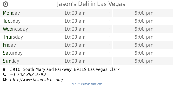
Jason's Deli
3910 South Maryland Parkway, Las Vegas
Restaurant
read more
666 m
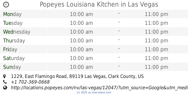
Popeyes Louisiana Kitchen
1229 East Flamingo Road, Las Vegas
Restaurant
read more
699 m
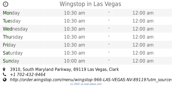
Wingstop
3910 South Maryland Parkway, Las Vegas
Restaurant
read more
776 m
Restaurant El Rey
3969 South Maryland Parkway, Las Vegas
Restaurant
read more
833 m
Ranch IHAW IHAW
3768 South Maryland Parkway, Las Vegas
Restaurant
read more
870 m
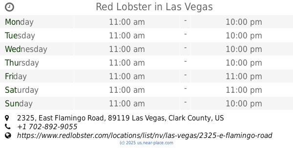
Red Lobster
2325 East Flamingo Road, Las Vegas
Restaurant
read more
976 m
La Flor Es Michoacan
4161 South Eastern Avenue, Las Vegas
Restaurant
read more
976 m
La Parrilla
4161 South Eastern Avenue # A11, Las Vegas
Restaurant
read more
📑
all categories
Accounting
Administrative area level 1
Administrative area level 2
Airport
Amusement park
Aquarium
Art gallery
Atm
Bakery
Bank
Bar
Beauty salon
Bicycle store
Book store
Bowling alley
Bus station
Cafe
Campground
Car dealer
Car rental
Car repair
Car wash
Casino
Cemetery
Church
City hall
Clothing store
Colloquial area
Convenience store
Courthouse
Dentist
Department store
Doctor
Electrician
Electronics store
Embassy
Establishment
Finance
Fire station
Florist
Food
Funeral home
Furniture store
Gas station
General contractor
Grocery or supermarket
Gym
Hair care
Hardware store
Health
Hindu Temple
Home goods store
Hospital
Insurance agency
Intersection
Jewelry store
Laundry
Lawyer
Library
Light rail station
Liquor store
Local government office
Locality
Locksmith
Lodging
Meal delivery
Meal takeaway
Mosque
Movie rental
Movie theater
Moving company
Museum
Natural feature
Neighborhood
Night club
Painter
Park
Parking
Pet store
Pharmacy
Physiotherapist
Place of worship
Plumber
Point of interest
Police
Political
Post office
Premise
Real estate agency
Restaurant
Roofing contractor
Route
Rv park, camping
School
Shoe store
Shopping mall
Spa
Stadium
Storage
Store
Subpremise
Subway station
Supermarket
Synagogue
Taxi stand
Train station
Transit station
Travel agency
University
Veterinary care
Zoo
administrative area level 3
sublocality level 1
↑