Park nearby Pinewood Park
United States
Park nearby Pinewood Park
Pinewood Park
Irvine, CA 92620, USA
contacts phone
:
+1
Latitude:
33.7044328
, Longitude:
-117.7569451
larger map & directions
read more
nearest Park
369 m
Jeffrey Open Space Trail
13252 Jeffrey Road, Irvine
Park
read more
424 m
Blue Gum Park
Irvine
Park
read more
485 m
Carrotwood Park
60 Bennington, Irvine
Park
read more
503 m
Lamplighter Park
39 Enchanted, Irvine
Park
read more
700 m
Alderwood Park
Irvine
Park
read more
739 m
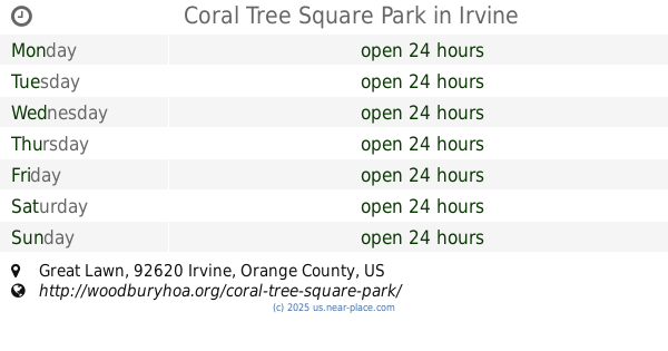
Coral Tree Square Park
&, Great Lawn & Spanish Lace, Irvine
Park
read more
806 m
Magnolia Square Park
184 Sanctuary, Irvine
Park
read more
811 m
Mosaic Park
165, Parkwood, Irvine
Park
read more
860 m
Pepperwood Park
55 Columbus, Irvine
Park
read more
894 m
Sycamore Park
Irvine
Park
read more
902 m
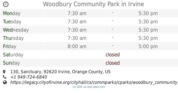
Woodbury Community Park
130 Sanctuary, Irvine
Park
read more
955 m
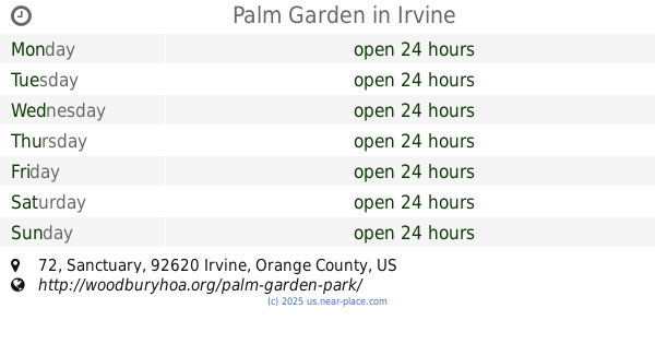
Palm Garden
72 Sanctuary, Irvine
Park
read more
1.27 km
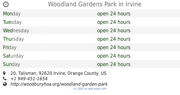
Woodland Gardens Park
20 Talisman, Irvine
Park
read more
1.288 km
Coralwood Park
Irvine
Park
read more
1.54 km
City of Irvine; Cypress Community Park
255 Visions, Irvine
Park
read more
📑
all categories
Accounting
Administrative area level 1
Administrative area level 2
Airport
Amusement park
Aquarium
Art gallery
Atm
Bakery
Bank
Bar
Beauty salon
Bicycle store
Book store
Bowling alley
Bus station
Cafe
Campground
Car dealer
Car rental
Car repair
Car wash
Casino
Cemetery
Church
City hall
Clothing store
Colloquial area
Convenience store
Courthouse
Dentist
Department store
Doctor
Electrician
Electronics store
Embassy
Establishment
Finance
Fire station
Florist
Food
Funeral home
Furniture store
Gas station
General contractor
Grocery or supermarket
Gym
Hair care
Hardware store
Health
Hindu Temple
Home goods store
Hospital
Insurance agency
Intersection
Jewelry store
Laundry
Lawyer
Library
Light rail station
Liquor store
Local government office
Locality
Locksmith
Lodging
Meal delivery
Meal takeaway
Mosque
Movie rental
Movie theater
Moving company
Museum
Natural feature
Neighborhood
Night club
Painter
Park
Parking
Pet store
Pharmacy
Physiotherapist
Place of worship
Plumber
Point of interest
Police
Political
Post office
Premise
Real estate agency
Restaurant
Roofing contractor
Route
Rv park, camping
School
Shoe store
Shopping mall
Spa
Stadium
Storage
Store
Subpremise
Subway station
Supermarket
Synagogue
Taxi stand
Train station
Transit station
Travel agency
University
Veterinary care
Zoo
administrative area level 3
sublocality level 1
↑