Park nearby Херитедж Филд
United States
Park nearby Херитедж Филд
Херитедж Филд
Бронкс, Нью-Йорк 10451, США
contacts phone
:
+1
website:
www.nycgovparks.org
Latitude:
40.82686
, Longitude:
-73.9278993
larger map & directions
read more
nearest Park
168 m
River Avenue Parks
802 River Avenue, Bronx
Park
read more
175 m
Парк Макомбс Дэм
East 157th Street & W. 161 St, Bronx
Park
read more
192 m
Баб Рут Плаза
1 East 161st Street, Bronx
Park
read more
443 m
Lou Gehrig Plaza
161 and, Grandview Place, Bronx
Park
read more
471 m
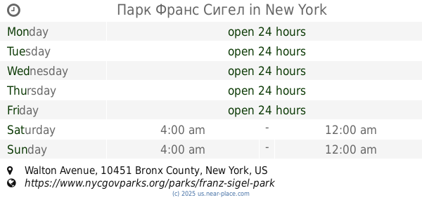
Парк Франс Сигел
Walton Avenue & Grand Concourse bet, Bronx
Park
read more
481 m
Пир 5
725 Exterior Street, Bronx
Park
read more
500 m
Joyce Kilmer Park
955 Walton Avenue, Bronx
Park
read more
514 m
Парк Джойс Килмер
955 Walton Avenue, Bronx
Park
read more
653 m
Парк Милл Понд
1, East 150th Street, Bronx
Park
read more
673 m
Bathgate Community Garden
1024 Woodycrest Avenue, Bronx
Park
read more
839 m
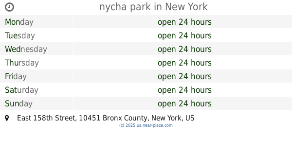
nycha park
East 158th Street, Bronx
Park
read more
1.034 km
811 Family and Friends Garden
327 East 158th Street, Bronx
Park
read more
1.104 km
Courtlandt Avenue Association Garden
366 East 158th Street, Bronx
Park
read more
1.144 km
Gladiator Park
40 West 143rd Street, New York
Park
read more
1.369 km
Morris-Jumel Community Garden
457 West 162nd Street, New York
Park
read more
📑
all categories
Accounting
Administrative area level 1
Administrative area level 2
Airport
Amusement park
Aquarium
Art gallery
Atm
Bakery
Bank
Bar
Beauty salon
Bicycle store
Book store
Bowling alley
Bus station
Cafe
Campground
Car dealer
Car rental
Car repair
Car wash
Casino
Cemetery
Church
City hall
Clothing store
Colloquial area
Convenience store
Courthouse
Dentist
Department store
Doctor
Electrician
Electronics store
Embassy
Establishment
Finance
Fire station
Florist
Food
Funeral home
Furniture store
Gas station
General contractor
Grocery or supermarket
Gym
Hair care
Hardware store
Health
Hindu Temple
Home goods store
Hospital
Insurance agency
Intersection
Jewelry store
Laundry
Lawyer
Library
Light rail station
Liquor store
Local government office
Locality
Locksmith
Lodging
Meal delivery
Meal takeaway
Mosque
Movie rental
Movie theater
Moving company
Museum
Natural feature
Neighborhood
Night club
Painter
Park
Parking
Pet store
Pharmacy
Physiotherapist
Place of worship
Plumber
Point of interest
Police
Political
Post office
Premise
Real estate agency
Restaurant
Roofing contractor
Route
Rv park, camping
School
Shoe store
Shopping mall
Spa
Stadium
Storage
Store
Subpremise
Subway station
Supermarket
Synagogue
Taxi stand
Train station
Transit station
Travel agency
University
Veterinary care
Zoo
administrative area level 3
sublocality level 1
↑