Night club nearby HHH
Coronavirus disease (COVID-19) Situation
confirmed cases
111820082
deaths
1219487
United States
Night club nearby HHH
HHH
114 Forrest Street Apt 3A, Buzzer #11, Brooklyn United States
contacts phone
:
+1
Latitude:
40.703055
, Longitude:
-73.932039
read more
nearest Night club
415 m
Mama Bella's Bar Lounge
457 Bushwick Avenue, Brooklyn
Night club
read more
426 m
Junxion
39 Knickerbocker Avenue, Brooklyn
Night club
read more
518 m
Tilt
248 McKibbin Street, Brooklyn
Night club
read more
634 m
The Holi Lot
485 Johnson Avenue, Brooklyn
Night club
read more
712 m
Market Hotel
1140 Myrtle Avenue, Brooklyn
Night club
read more
796 m
Sutherland
260 Meserole Street, Brooklyn
Night club
read more
825 m
House of Yes
2 Wyckoff Avenue, Brooklyn
Night club
read more
924 m
Secret Garden
25 Meadow Street, Brooklyn
Night club
read more
983 m
Privilege
140 Graham Avenue, Brooklyn
Night club
read more
990 m
Shisha Shack
1092 Broadway, Brooklyn
Night club
read more
1.029 km
Zone One
1311, 599 Johnson Avenue, Brooklyn
Night club
read more
1.041 km
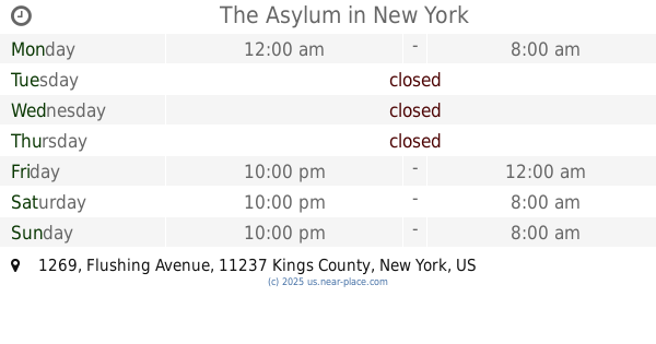
The Asylum
1269 Flushing Avenue, Brooklyn
Night club
read more
1.041 km
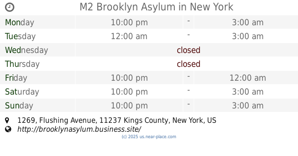
M2 Brooklyn Asylum
1269 Flushing Avenue, Brooklyn
Night club
read more
1.068 km
Starr Space
309 Starr Street, Brooklyn
Night club
read more
1.114 km
PS 160
160 Scholes Street, Brooklyn
Night club
read more
1.32 km
Times quares
82 Bleecker Street, Brooklyn
Night club
read more
1.418 km
Soundpark
224 Manhattan Avenue, Brooklyn
Night club
read more
1.467 km
LP & Harmony
683 Grand Street, Brooklyn
Night club
read more
1.48 km
The Gateway
1272 Broadway, Brooklyn
Night club
read more
1.942 km
Chez Otto
960 Madison Street, Brooklyn
Night club
read more
2.018 km
Black Flamingo
168 Borinquen Place, New York
Night club
read more
2.052 km
Baby Grand
424 Grand Street, Brooklyn
Night club
read more
2.177 km
NakedChill
931-869 Hancock Street, Brooklyn
Night club
read more
2.588 km
Vintage
482-504 Driggs Avenue, Brooklyn
Night club
read more
2.735 km
The Bedford
110 Bedford Avenue, Brooklyn
Night club
read more
📑
all categories
Accounting
Administrative area level 1
Administrative area level 2
Airport
Amusement park
Aquarium
Art gallery
Atm
Bakery
Bank
Bar
Beauty salon
Bicycle store
Book store
Bowling alley
Bus station
Cafe
Campground
Car dealer
Car rental
Car repair
Car wash
Casino
Cemetery
Church
City hall
Clothing store
Colloquial area
Convenience store
Courthouse
Dentist
Department store
Doctor
Electrician
Electronics store
Embassy
Establishment
Finance
Fire station
Florist
Food
Funeral home
Furniture store
Gas station
General contractor
Grocery or supermarket
Gym
Hair care
Hardware store
Health
Hindu Temple
Home goods store
Hospital
Insurance agency
Intersection
Jewelry store
Laundry
Lawyer
Library
Light rail station
Liquor store
Local government office
Locality
Locksmith
Lodging
Meal delivery
Meal takeaway
Mosque
Movie rental
Movie theater
Moving company
Museum
Natural feature
Neighborhood
Night club
Painter
Park
Parking
Pet store
Pharmacy
Physiotherapist
Place of worship
Plumber
Point of interest
Police
Political
Post office
Premise
Real estate agency
Restaurant
Roofing contractor
Route
Rv park, camping
School
Shoe store
Shopping mall
Spa
Stadium
Storage
Store
Subpremise
Subway station
Supermarket
Synagogue
Taxi stand
Train station
Transit station
Travel agency
University
Veterinary care
Zoo
administrative area level 3
sublocality level 1
↑