Local government office nearby WJNYC
United States
Local government office nearby WJNYC
WJNYC
338 21st Street, Brooklyn Израиль
contacts phone
:
+1
Latitude:
40.6591229
, Longitude:
-73.9900849
read more
nearest Local government office
463 m
Gary Spaier Company
594 6th Avenue #3, Brooklyn
Local government office
read more
758 m
Assembly Member James Brennan
416 7th Avenue, Brooklyn
Local government office
read more
982 m
NYC Dot
50 21st Street, Brooklyn
Local government office
read more
1.123 km
Brad Lander For City Council
456 5th Avenue & 3rd Floor, Brooklyn
Local government office
read more
1.127 km
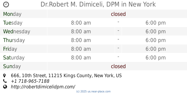
Dr.Robert M. Dimiceli, DPM
666 10th Street, Brooklyn
Local government office
read more
1.29 km
NYC Transit System
871 5th Avenue, Brooklyn
Local government office
read more
1.375 km
New York City Office
127 2nd Avenue, Brooklyn
Local government office
read more
1.533 km
Telesis Corporation
119 8th Street #301, Brooklyn
Local government office
read more
1.653 km
New York City Transit Auth
58 2nd Avenue, Brooklyn
Local government office
read more
1.784 km
Brooklyn Community Board 7
4201 4th Avenue, Brooklyn
Local government office
read more
1.838 km
Boro Park Courts Associates
966 42nd Street, Brooklyn
Local government office
read more
2.14 km
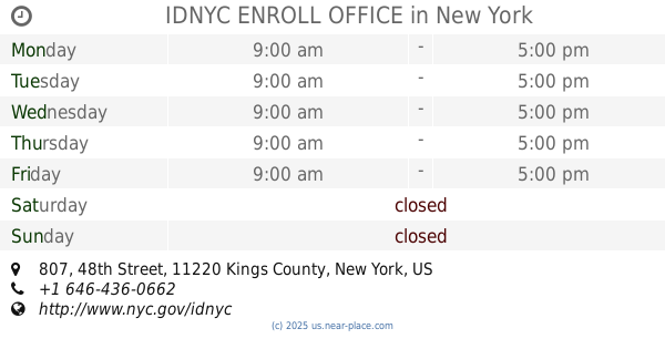
IDNYC ENROLL OFFICE
807 48th Street, Brooklyn
Local government office
read more
2.305 km
Le Metro Housing Corporation
25 8th Avenue, Brooklyn
Local government office
read more
2.323 km
235 Lincoln Housing Co-Op
235 Lincoln Place, Brooklyn
Local government office
read more
2.391 km
Assembly Member Felix W Ortiz
5004 4th Avenue, Brooklyn
Local government office
read more
📑
all categories
Accounting
Administrative area level 1
Administrative area level 2
Airport
Amusement park
Aquarium
Art gallery
Atm
Bakery
Bank
Bar
Beauty salon
Bicycle store
Book store
Bowling alley
Bus station
Cafe
Campground
Car dealer
Car rental
Car repair
Car wash
Casino
Cemetery
Church
City hall
Clothing store
Colloquial area
Convenience store
Courthouse
Dentist
Department store
Doctor
Electrician
Electronics store
Embassy
Establishment
Finance
Fire station
Florist
Food
Funeral home
Furniture store
Gas station
General contractor
Grocery or supermarket
Gym
Hair care
Hardware store
Health
Hindu Temple
Home goods store
Hospital
Insurance agency
Intersection
Jewelry store
Laundry
Lawyer
Library
Light rail station
Liquor store
Local government office
Locality
Locksmith
Lodging
Meal delivery
Meal takeaway
Mosque
Movie rental
Movie theater
Moving company
Museum
Natural feature
Neighborhood
Night club
Painter
Park
Parking
Pet store
Pharmacy
Physiotherapist
Place of worship
Plumber
Point of interest
Police
Political
Post office
Premise
Real estate agency
Restaurant
Roofing contractor
Route
Rv park, camping
School
Shoe store
Shopping mall
Spa
Stadium
Storage
Store
Subpremise
Subway station
Supermarket
Synagogue
Taxi stand
Train station
Transit station
Travel agency
University
Veterinary care
Zoo
administrative area level 3
sublocality level 1
↑