Local government office nearby Victim Assistance Centre & SAFE Program
Coronavirus disease (COVID-19) Situation
confirmed cases
111820082
deaths
1219487
United States
Local government office nearby Victim Assistance Centre & SAFE Program
Victim Assistance Centre & SAFE Program
1310, Prairie Street, 77002, Houston, Harris County, US United States
contacts phone
:
+1 713-274-7391
website:
safesupervised.com
Latitude:
29.758799
, Longitude:
-95.35927
larger map & directions
read more
nearest Local government office
278 m
Honorable Josefina Rendon
201 Caroline Street, Houston
Local government office
read more
288 m
Honorable Caroline E Baker
201 Caroline Street, Houston
Local government office
read more
288 m
Honorable A Smoots-Hogan
201 Caroline Street, Houston
Local government office
read more
288 m
Honorable Tony Lindsay
201 Caroline Street # 1400, Houston
Local government office
read more
288 m
Honorable Ken Wise
201 Caroline Street # 1110, Houston
Local government office
read more
288 m
Honorable Lisa Millard
201 Caroline Street, Houston
Local government office
read more
330 m
Harris County Infrastructure
1001 Preston Street, Houston
Local government office
read more
332 m
Harris County Precinct 4
1001 Preston #950, Houston
Local government office
read more
332 m
Harris County Auditor's Office
1001 Preston Street # 800, Houston
Local government office
read more
376 m
Honorable David Mendoza
1115 Congress Avenue # 312, Houston
Local government office
read more
396 m
Honorable Margaret S Harris
1201 Franklin Street, Houston
Local government office
read more
591 m
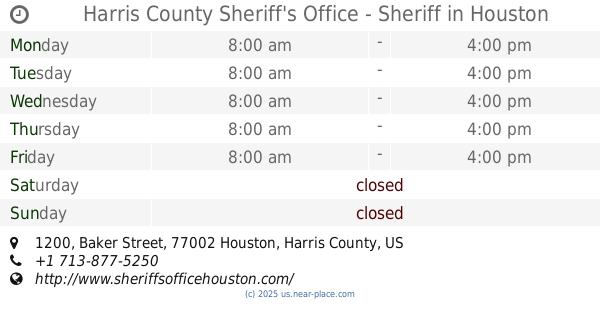
Harris County Sheriff's Office - Sheriff
1200 Baker Street, Houston
Local government office
read more
832 m
Honorable Frances Stacy
515 Rusk Street, Houston
Local government office
read more
832 m
Honorable Gray Miller
515 Rusk Street # 9136, Houston
Local government office
read more
865 m
Downtown Vehicular Wayfinding
300 Smith Street, Houston
Local government office
read more
📑
all categories
Accounting
Administrative area level 1
Administrative area level 2
Airport
Amusement park
Aquarium
Art gallery
Atm
Bakery
Bank
Bar
Beauty salon
Bicycle store
Book store
Bowling alley
Bus station
Cafe
Campground
Car dealer
Car rental
Car repair
Car wash
Casino
Cemetery
Church
City hall
Clothing store
Colloquial area
Convenience store
Courthouse
Dentist
Department store
Doctor
Electrician
Electronics store
Embassy
Establishment
Finance
Fire station
Florist
Food
Funeral home
Furniture store
Gas station
General contractor
Grocery or supermarket
Gym
Hair care
Hardware store
Health
Hindu Temple
Home goods store
Hospital
Insurance agency
Intersection
Jewelry store
Laundry
Lawyer
Library
Light rail station
Liquor store
Local government office
Locality
Locksmith
Lodging
Meal delivery
Meal takeaway
Mosque
Movie rental
Movie theater
Moving company
Museum
Natural feature
Neighborhood
Night club
Painter
Park
Parking
Pet store
Pharmacy
Physiotherapist
Place of worship
Plumber
Point of interest
Police
Political
Post office
Premise
Real estate agency
Restaurant
Roofing contractor
Route
Rv park, camping
School
Shoe store
Shopping mall
Spa
Stadium
Storage
Store
Subpremise
Subway station
Supermarket
Synagogue
Taxi stand
Train station
Transit station
Travel agency
University
Veterinary care
Zoo
administrative area level 3
sublocality level 1
↑