Hospital nearby Beyan Lorpu
United States
Hospital nearby Beyan Lorpu
Beyan Lorpu
3630, East Imperial Highway, 90262, Lynwood, Los Angeles County, US United States
contacts phone
:
+1 310-900-8900
website:
www.stfrancismedicalcenter.org
Latitude:
33.9294999
, Longitude:
-118.2033185
larger map & directions
read more
nearest Hospital
2.958 km
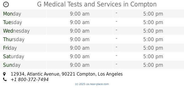
G Medical Tests and Services
12934 Atlantic Avenue, Compton
Hospital
Point of interest
Health
Establishment
read more
3.103 km
May Family Medical
711 Rosecrans Avenue, Compton
Hospital
Point of interest
Health
Establishment
read more
3.759 km
St. Anthony Medical Centers
1145 East Compton Boulevard, Compton
Hospital
Doctor
Health
Point of interest
Establishment
read more
4.344 km
JESSICA BARRAGAN
349 West Compton Boulevard, Compton
Hospital
Point of interest
Health
Establishment
read more
4.798 km
Medical Alondra
211-273 East Alondra Boulevard, Compton
Hospital
Health
Point of interest
Establishment
read more
4.894 km
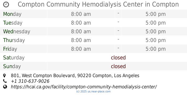
Compton Community Hemodialysis Center
801 West Compton Boulevard, Compton
Hospital
Doctor
Health
Point of interest
Establishment
read more
12.205 km
Long Beach Healthcare Center
3401 Cedar Avenue, Long Beach
Hospital
read more
12.353 km
Los Coyotes Imaging Center
552 E Carson Street, Carson
Hospital
Health
Point of interest
Establishment
read more
13.446 km
kp sunset
852 South Broadway, Los Angeles
Hospital
read more
13.659 km
Downtown Urgent Care
267 South San Pedro Street, Los Angeles
Hospital
read more
14.692 km
Keck Hospital of University of Southern California
1500 San Pablo Street, Los Angeles
Hospital
read more
14.901 km
Parking For Good Samaritan Hospital
636 Lucas Avenue, Los Angeles
Hospital
read more
15.016 km
Doctor De Los Ojos
1245 Wilshire Boulevard, Los Angeles
Hospital
read more
15.587 km
변성래 내과
2120 West 8th Street, Los Angeles
Hospital
read more
17.487 km
LA Medical Center
3663 West 6th Street, Los Angeles
Hospital
read more
📑
all categories
Accounting
Administrative area level 1
Administrative area level 2
Airport
Amusement park
Aquarium
Art gallery
Atm
Bakery
Bank
Bar
Beauty salon
Bicycle store
Book store
Bowling alley
Bus station
Cafe
Campground
Car dealer
Car rental
Car repair
Car wash
Casino
Cemetery
Church
City hall
Clothing store
Colloquial area
Convenience store
Courthouse
Dentist
Department store
Doctor
Electrician
Electronics store
Embassy
Establishment
Finance
Fire station
Florist
Food
Funeral home
Furniture store
Gas station
General contractor
Grocery or supermarket
Gym
Hair care
Hardware store
Health
Hindu Temple
Home goods store
Hospital
Insurance agency
Intersection
Jewelry store
Laundry
Lawyer
Library
Light rail station
Liquor store
Local government office
Locality
Locksmith
Lodging
Meal delivery
Meal takeaway
Mosque
Movie rental
Movie theater
Moving company
Museum
Natural feature
Neighborhood
Night club
Painter
Park
Parking
Pet store
Pharmacy
Physiotherapist
Place of worship
Plumber
Point of interest
Police
Political
Post office
Premise
Real estate agency
Restaurant
Roofing contractor
Route
Rv park, camping
School
Shoe store
Shopping mall
Spa
Stadium
Storage
Store
Subpremise
Subway station
Supermarket
Synagogue
Taxi stand
Train station
Transit station
Travel agency
University
Veterinary care
Zoo
administrative area level 3
sublocality level 1
↑